
Archivo: Mexico Durango location map

Tamaño de esta previsualización PNG del archivo SVG: 561 × 535 píxeles. Otra resolución: 252 × 240 píxeles.
Archivo original (archivo SVG, nominalmente 561 × 535 píxeles, tamaño de archivo: 748 KB)
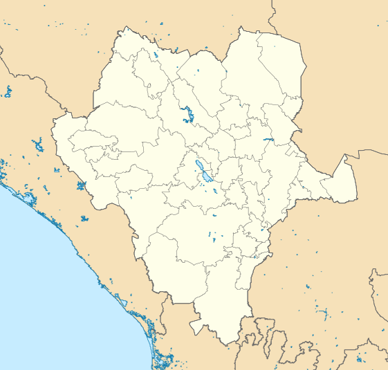
Description: Location Map of Durango EPSG:3857 projection, Geographic limits of the map: N: 27.20° N S: 22.00° N W: 108.00° W E: 102.00° W
Title: Mexico Durango location map
Credit: Sources of data: INEGI, Marco Geoestadístico Nacional, 2014. (Free use of the data)
Author: Addicted04
Usage Terms: Creative Commons Attribution-Share Alike 4.0
License: CC BY-SA 4.0
License Link: https://creativecommons.org/licenses/by-sa/4.0
Attribution Required?: Yes
Usos del archivo
Las siguientes páginas enlazan a este archivo:
- Aeropuerto Internacional de Durango
- Anexo:Patrimonio de la Humanidad en México
- Benito Juárez (Juárez de Abajo)
- Bermejillo
- Canelas (Durango)
- Ciudad Guadalupe Victoria (Durango)
- Ciudad Juárez (Durango)
- Ciudad Lerdo
- Cuencamé
- Dinamita (Durango)
- El Crucero (Durango)
- El Refugio (El Burro)
- El Salto (Durango)
- El Tizonazo
- Emiliano Zapata (Durango)
- General Simón Bolívar (Durango)
- Guanaceví
- Gómez Palacio
- Ignacio Allende (Durango)
- La Coyotada
- La Rosilla
- La Tembladora de Camellones
- Mapimí
- Mil Diez (Durango)
- Museo de Arqueología Ganot-Peschard
- Nazareno (Durango)
- Nazas
- Nombre de Dios (Durango)
- Peñón Blanco
- Rodeo (Durango)
- Río Grande (Durango)
- San Francisco del Mezquital
- San José de Nazareno (Durango)
- San Juan de Guadalupe (Durango)
- San Juan del Río del Centauro del Norte
- San Pedro del Gallo
- Santa Bárbara (Durango)
- Santa Clara (Durango)
- Santa María del Oro (Durango)
- Santiago Papasquiaro
- Tamazula de Victoria
- Tayoltita
- Tlahualilo de Zaragoza
- Vicente Guerrero (Durango)
- Victoria de Durango
- Villa Ocampo (Durango)
- Villa Unión (Durango)

Todo el contenido de los artículos de la Enciclopedia Kiddle (incluidas las imágenes) se puede utilizar libremente para fines personales y educativos bajo la licencia Atribución-CompartirIgual a menos que se indique lo contrario.