
Archivo: Guatemala department location map

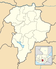
Description: Location map of the Guatemala department, Guatemala. Equirectangular projection, geographic limits of the map: N: 14°56'49.82"N S: 14°10'59.56"N W: 90°48'11.69"O E: 90° 9'41.82"O
Title: Guatemala department location map
Credit: Own work based on: Guatemala location map.svg by Spischot. Rivers and lakes from OpenStreetMap by © OpenStreetMap contributors. National, departmental and municipal boundaries from the Infraestructura de Datos Espaciales de Guatemala (IDEG) website, a Guatemalan national geographic information system, whose data is on the public domain according to the Legislative Decree 42-2001 of the Congress of Guatemala.
Author: Derivative work by Edgouno
Usage Terms: Creative Commons Attribution-Share Alike 3.0
License: CC BY-SA 3.0
License Link: https://creativecommons.org/licenses/by-sa/3.0
Attribution Required?: Yes
Usos del archivo
Las siguientes páginas enlazan a este archivo:
- Amatitlán (Guatemala)
- Bárcena (Villa Nueva)
- Caserío Concepción Rabanales
- Castañas (Villa Nueva)
- Chinautla
- Chuarrancho
- Ciudad Cayalá (Guatemala)
- Ciudad Peronia
- Ciudad Real (Villa Nueva)
- El Frutal (Villa Nueva)
- Fraijanes
- Kaminaljuyú
- Mixco
- Monte María (Villa Nueva)
- Palencia (Guatemala)
- Parque nacional Naciones Unidas
- San José Pinula
- San José del Golfo
- San Juan Sacatepéquez
- San Miguel Petapa
- San Pedro Ayampuc
- San Pedro Sacatepéquez (Guatemala)
- San Raymundo
- Santa Catarina Pinula
- Villa Canales
- Villa Lobos (Villa Nueva)
- Villa Nueva (Guatemala)
