
Archivo: Ethnographic Iberia 200 BCE-es

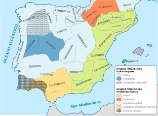
Descripción: Ethnographic and Linguistic Map of the Iberian Peninsula at about 200 BCE (at the end of the Second Punic War). Based on the map done by Portuguese Archeologist Luís Fraga (luisfraga@arqueotavira.com), from the "Campo Arqueológico de Tavira" (Tavira Archeological Camp - official site), in Tavira, Algarve - Portugal. The reference map can be found at this location, and a pdf version, with extensive and detailed information on the criteria used, as well as the long bibliography used to source the map can be found [http://www.arkeotavira.com/Mapas/Iberia/Populi.pdf here
Título: Ethnographic Iberia 200 BCE-es
Créditos: Ethnographic Iberia 200 BCE.PNG MapaTopográficoDeAsiaMenor.svg
Autor(a): Ethnographic Iberia 200 BCE.PNG: The Ogre Iberia 300BC-es.svg: Rowanwindwhistler derivative work: Rowanwindwhistler (discusión)
Términos de Uso: Creative Commons Attribution-Share Alike 4.0
Licencia: CC BY-SA 4.0
Enlace de Licencia: https://creativecommons.org/licenses/by-sa/4.0
¿Se exige la atribución?: Sí
Usos del archivo
Las siguientes páginas enlazan a este archivo:
