
Archivo: Retalhuleu department location map

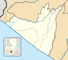
Description: Location map of the Retalhuleu department, Guatemala. Equirectangular projection, geographic limits of the map: N: 14°44'56.56"N S: 14° 4'49.65"N W: 92°12'45.00"O E: 91°26'48.82"O
Title: Retalhuleu department location map
Credit: Own work based on: Guatemala location map.svg by Spischot. Rivers and lakes from OpenStreetMap by © OpenStreetMap contributors. National, departmental and municipal boundaries from the Infraestructura de Datos Espaciales de Guatemala (IDEG) website, a Guatemalan national geographic information system, whose data is on the public domain according to the Legislative Decree 42-2001 of the Congress of Guatemala.
Author: Derivative work by Edgouno
Usage Terms: Creative Commons Attribution-Share Alike 3.0
License: CC BY-SA 3.0
License Link: https://creativecommons.org/licenses/by-sa/3.0
Attribution Required?: Yes
Usos del archivo
Las siguientes páginas enlazan a este archivo:
