
Anexo:Registro Nacional de Lugares Históricos en Brooklyn para niños
Esta lista muestra 157 lugares y áreas especiales en Brooklyn, Nueva York, que están registrados en el Registro Nacional de Lugares Históricos. Estos lugares son importantes porque nos cuentan historias sobre el pasado y la cultura de la ciudad.
El Servicio de Parques Nacionales es la organización que se encarga de mantener esta lista. La información que ves aquí está actualizada hasta el 7 de septiembre de 2012.
Contenido
Lugares Históricos de Brooklyn
Aquí puedes encontrar una lista de algunos de los lugares más interesantes y significativos de Brooklyn que han sido reconocidos por su valor histórico.
Estaciones de Metro Históricas
Varias estaciones de metro en Brooklyn son más que simples paradas; son parte de la historia del transporte de la ciudad.
- 15th Street – Prospect Park Subway Station (IND)
* Ubicación: 15th St./Prospect Park W and SW, Brooklyn * Fecha de registro: 27 de julio de 2005
*

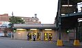
- Fourth Avenue Station (IND)
* Ubicación: Entre 3rd y 4th Aves., y 10th y 11th Sts., Brooklyn * Fecha de registro: 6 de julio de 2005
*

- Ninth Avenue Station (Dual System BRT)
* Ubicación: 38th St. y 9th Ave. cerca de la unión de New Utrecht Ave., Sunset Park * Fecha de registro: 6 de julio de 2005
*

- Atlantic Avenue Control House
* Ubicación: Flatbush y Atlantic Aves., Downtown Brooklyn * Fecha de registro: 6 de mayo de 1980
*

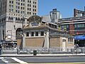
- Atlantic Avenue Subway Station (IRT and BMT)
* Ubicación: Cruce de Flatbush Ave. en Atlantic y 4th Aves., Downtown Brooklyn * Fecha de registro: 17 de septiembre de 2004
*
- Avenue U Station (Dual System BRT)
* Ubicación: Entre Ave. U y Ave. T y 7th y 8th Sts., Brooklyn * Fecha de registro: 6 de julio de 2005
*

- Bay Parkway Station (Dual System BRT)
* Ubicación: Sobre Bay Parkway en 86th St., Brooklyn * Fecha de registro: 6 de julio de 2005
*

- Beverley Road Subway Station (BRT pre-Dual System)
* Ubicación: Beverley Rd. en Marlborough Rd., Flatbush * Fecha de registro: 17 de septiembre de 2004
*

- Borough Hall Subway Station (IRT)
* Ubicación: Cruce de Joralemon, Court y Adams Sts., Downtown Brooklyn * Fecha de registro: 17 de septiembre de 2004
*

- New Utrecht Avenue Station (Dual System BRT)
* Ubicación: Debajo del cruce de New Utrecht Ave. con 15th Ave. y 62nd St., Brooklyn * Fecha de registro: 6 de julio de 2005
*

- Ocean Parkway Station (Dual System BRT)
* Ubicación: Sobre el cruce de Brighton Beach Ave. y Ocean Pkwy, Brighton Beach * Fecha de registro: 29 de julio de 2005
*

- Substation #401
* Ubicación: 3046 Fulton St. entre Essex St. y Shepherd Ave., East New York * Fecha de registro: 6 de julio de 2005
- Wilson Avenue Subway Station (Dual System BMT)
* Ubicación: Chauncey St. en Wilson Ave., Bushwick * Fecha de registro: 6 de julio de 2005
*

Edificios y Lugares Emblemáticos
Brooklyn tiene muchos edificios y sitios que son importantes por su arquitectura o por los eventos que allí ocurrieron.
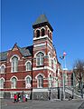
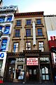
- 68th Police Precinct Station House and Stable
* Ubicación: 4302 4th Ave., Sunset Park * Fecha de registro: 3 de junio de 1982
*

- 75th Police Precinct Station House
* Ubicación: 484 Liberty Ave., Brooklyn * Fecha de registro: 10 de septiembre de 2007
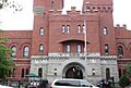
- 83rd Precinct Police Station and Stable
* Ubicación: 179 Wilson Ave., Nueva York * Fecha de registro: 14 de abril de 1982
*

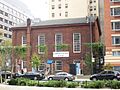
- Andrews United Methodist Church
* Ubicación: 95 Richmond St., East New York * Fecha de registro: 22 de enero de 1992
- Astral Apartments
* Ubicación: 184 Franklin St., Greenpoint * Fecha de registro: 29 de octubre de 1982
*

- Atlantic Avenue Tunnel
* Ubicación: Debajo de Atlantic Ave. entre Boerum Pl. y Columbia St., Cobble Hill * Fecha de registro: 7 de septiembre de 1989
*

- Austin, Nichols and Company Warehouse
* Ubicación: 184 Kent Ave., Williamsburg * Fecha de registro: 28 de junio de 2007
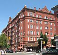
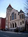
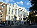
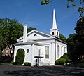
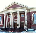
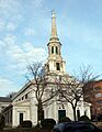
- Baptist Temple (Brooklyn, New York)
* Ubicación: 360 Schermerhorn St., Downtown Brooklyn * Fecha de registro: 20 de noviembre de 1995
*

- Bay Ridge United Methodist Church
* Ubicación: 7002 Fourth St., Bay Ridge * Fecha de registro: 9 de septiembre de 1999
- Beth El Jewish Center of Flatbush
* Ubicación: 1981 Homecrest Ave., Flatbush * Fecha de registro: 29 de mayo de 2009
*

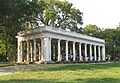
- Boathouse on the Lullwater of the Lake in Prospect Park
* Ubicación: Prospect Park, Prospect Park (Brooklyn) * Fecha de registro: 7 de enero de 1972
*

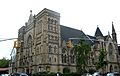
- Boy's High School
* Ubicación: 832 Marcy Ave., Bedford-Stuyvesant * Fecha de registro: 25 de febrero de 1982
*

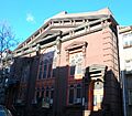
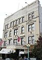
- Brooklyn Academy of Music
* Ubicación: 30 Lafayette Ave., Fort Greene * Fecha de registro: 2 de mayo de 2006
*

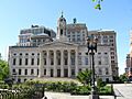
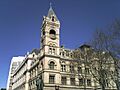
- Brooklyn Borough Hall
* Ubicación: 209 Joralemon St., Downtown Brooklyn * Fecha de registro: 10 de enero de 1980
*

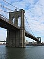
- Brooklyn Bridge
* Ubicación: Cruza el East River de Brooklyn a Manhattan, Brooklyn * Fecha de registro: 15 de octubre de 1966
*

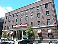
- Brooklyn Historical Society
* Ubicación: 128 Pierrepont St., Brooklyn Heights * Fecha de registro: 17 de julio de 1991
*

- Museo de Brooklyn
* Ubicación: Eastern Parkway y Washington Ave., Prospect Heights * Fecha de registro: 22 de agosto de 1977
*

- Edificio de la Biblioteca Pública de Brooklyn-Edificio Central
* Ubicación: Grand Army Plaza, Brooklyn * Fecha de registro: 11 de enero de 2002
*

- Edificio de la Brooklyn Trust Company
* Ubicación: 177 Montague St., Brooklyn Heights * Fecha de registro: 20 de agosto de 2009
*

- Buildings at 375-379 Flatbush Avenue and 185-187 Sterling Place
* Ubicación: 375-379 Flatbush Ave. y 185-187 Sterling Pl., Brooklyn * Fecha de registro: 7 de septiembre de 1984
- Casemate Fort, Whiting Quadrangle
* Ubicación: Fort Hamilton, cerca de NY 27, Brooklyn * Fecha de registro: 7 de agosto de 1974
*

- Christ Evangelical English Lutheran Church
* Ubicación: 1084 Lafayette Ave., Brooklyn * Fecha de registro: 30 de agosto de 2007
*

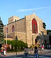
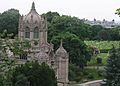
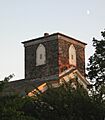
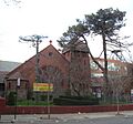
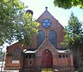
- Church of the Holy Innocents
* Ubicación: 279 E. 17th St., Flatbush * Fecha de registro: 16 de junio de 2005
*

- Coney Island Fire Station Pumping Station
* Ubicación: 2301 Neptune Ave., Coney Island * Fecha de registro: 8 de diciembre de 1981
*

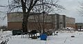
- Coney Island Yard Electric Motor Repair Shop
* Ubicación: Esquina SW de Avenue X y Shell Rd., Brooklyn * Fecha de registro: 9 de febrero de 2006
- Coney Island Yard Gatehouse
* Ubicación: Esquina SW de Shell Rd. y Avenue X, Brooklyn * Fecha de registro: 9 de febrero de 2006
*

- Congregation Beth Israel
* Ubicación: 203 E. 37th St., Brooklyn * Fecha de registro: 30 de abril de 2009
- Congregational Church of the Evangel
* Ubicación: 1950 Bedford Ave., Brooklyn * Fecha de registro: 11 de diciembre de 2009
- Congregation Tifereth Israel
* Ubicación: 1320 Eight Ave., Brooklyn * Fecha de registro: 11 de enero de 2002
*

- Casa William B. Cronyn
* Ubicación: 271 9th St., Nueva York * Fecha de registro: 3 de junio de 1982
*

- Cuyler Presbyterian Church
* Ubicación: 358-360 Pacific St., Brooklyn * Fecha de registro: 23 de marzo de 2001
*

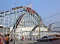
- Cyclone Roller Coaster
* Ubicación: 834 Surf Ave. en W. 10th St., Coney Island * Fecha de registro: 25 de junio de 1991
*

- Cypress Hills National Cemetery
* Ubicación: 625 Jamaica Ave., Brooklyn * Fecha de registro: 13 de noviembre de 1997
*

- East Midwood Jewish Center
* Ubicación: 1625 Ocean Ave., Midwood * Fecha de registro: 7 de junio de 2006
*

- Eastern Parkway
* Ubicación: Eastern Pkwy desde Grand Army Plaza hasta Ralph Ave., Brooklyn * Fecha de registro: 26 de septiembre de 1983
*

- Eighth Avenue (14th Brooklyn Regiment) Armory
* Ubicación: 1402 Eighth Ave., Park Slope * Fecha de registro: 14 de abril de 1994
*

- Emmanuel Baptist Church
* Ubicación: 279 LaFayette Ave., Brooklyn * Fecha de registro: 16 de diciembre de 1977
*

- Erasmus Hall Academy
* Ubicación: Entre Flatbush, Bedford, Church y Snyder Aves., Flatbush * Fecha de registro: 11 de noviembre de 1975
*

- Evergreens Cemetery
* Ubicación: 1629 Bushwick Ave., Brooklyn * Fecha de registro: 15 de noviembre de 2007
*

- Edificio Federal y Oficina Postal
* Ubicación: 271 Cadman Plaza, E., Downtown Brooklyn * Fecha de registro: 9 de octubre de 1974
*

- Feuchtwanger Stable
* Ubicación: 159 Carlton Ave., Brooklyn * Fecha de registro: 20 de marzo de 1986
- Flatbush Dutch Reformed Church Complex
* Ubicación: 890 Flatbush Ave. y 2101-2103 Kenmore Terr., Flatbush * Fecha de registro: 8 de septiembre de 1983
*

- Flatbush Town Hall
* Ubicación: 35 Snyder Ave., Flatbush * Fecha de registro: 24 de julio de 1972
*

- Flatlands Dutch Reformed Church
* Ubicación: Kings Hwy. y E. 40th St., Flatlands * Fecha de registro: 30 de agosto de 1979
*

- Friends Meetinghouse and School
* Ubicación: 110 Schermerhorn St., Downtown Brooklyn * Fecha de registro: 4 de noviembre de 1982
*

- Gage and Tollner Restaurant
* Ubicación: 372 Fulton St., Downtown Brooklyn * Fecha de registro: 3 de junio de 1982
*

- Grecian Shelter
* Ubicación: Prospect Park cerca de Parkside Ave., Prospect Park * Fecha de registro: 20 de enero de 1972
*

- Green-Wood Cemetery
* Ubicación: 500 25th Street, Brooklyn * Fecha de registro: 8 de marzo de 1997
*

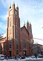
- Hanson Place Seventh Day Adventist Church
* Ubicación: 88 Hanson Pl., Nueva York * Fecha de registro: 23 de abril de 1980
*

- Holy Trinity Church (Protestant Episcopal)
* Ubicación: 157 Montague St., Brooklyn Heights * Fecha de registro: 23 de diciembre de 1987
*

- Houses at 216-264 Ovington Ave.
* Ubicación: 216-264 Ovington Ave., Brooklyn * Fecha de registro: 5 de junio de 2007
- Casa Hubbard
* Ubicación: 2138 McDonald Ave., Brooklyn * Fecha de registro: 2 de junio de 2000
- Immanuel Congregational Church
* Ubicación: 461 Decatur St., Bedford–Stuyvesant * Fecha de registro: 7 de junio de 2006
- Industrial Complex at 221 McKibbin Street
* Ubicación: 221 McKibbin St., Brooklyn * Fecha de registro: 12 de mayo de 2009
- Jewish Center of Kings Highway
* Ubicación: 1202-1218 Ave. P, Brooklyn * Fecha de registro: 12 de febrero de 2010
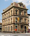
- Kings County Savings Bank
* Ubicación: 135 Broadway, Williamsburg * Fecha de registro: 16 de abril de 1980
*

- Kingsway Jewish Center
* Ubicación: 2810 Nostrand Ave., Brooklyn * Fecha de registro: 12 de febrero de 2010
- Knickerbocker Field Club
* Ubicación: 114 E. 18th St., Nueva York * Fecha de registro: 29 de octubre de 1982
- Kol Israel Synagogue
* Ubicación: 603 St. John's Place, Brooklyn * Fecha de registro: 2 de diciembre de 2009
*

- Casa Lefferts-Laidlaw
* Ubicación: 136 Clinton St., Brooklyn Heights * Fecha de registro: 12 de septiembre de 1985
- Lincoln Club
* Ubicación: 65 Putnam Ave., Brooklyn * Fecha de registro: 27 de enero de 1983
*

- Litchfield Villa
* Ubicación: Prospect Park W. y 5th St., Prospect Park * Fecha de registro: 14 de septiembre de 1977
*

- Loew's Kings Theatre
* Ubicación: 1027 Flatbush Ave, Flatbush * Fecha de registro: 22 de agosto de 2012
*

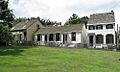
- Casa Hendrick I. Lott
* Ubicación: 1940 E. 36th St., Marine Park * Fecha de registro: 3 de marzo de 1994
*

- Magen David Synagogue
* Ubicación: 2017 67th St., Bensonhurst * Fecha de registro: 15 de abril de 2004
- Manhattan Bridge
* Ubicación: Cruza el East River entre Front y Canal St., Downtown Brooklyn * Fecha de registro: 30 de agosto de 1983
*

- Monsignor McGolrick Park and Shelter Pavilion
* Ubicación: Bordeado por Nassau y Driggs Aves., Russell y Monitor Sts., Greenpoint * Fecha de registro: 6 de mayo de 1980
*

- New England Congregational Church and Rectory
* Ubicación: 177-179 S. 9th St., Williamsburg * Fecha de registro: 15 de septiembre de 1983
*

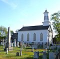
- New Lots Reformed Church and Cemetery
* Ubicación: 630 New Lots Ave., New Lots * Fecha de registro: 19 de mayo de 1983
*

- New Utrecht Reformed Church and Buildings
* Ubicación: 18th Ave. y 83rd St., New Utrecht * Fecha de registro: 9 de abril de 1980
*

- New York Congregational Home for the Aged
* Ubicación: 123 Linden Blvd., Brooklyn * Fecha de registro: 5 de noviembre de 2008
- Ocean Parkway
* Ubicación: Desde Church Ave. hasta Seabreeze Ave., Brooklyn * Fecha de registro: 8 de septiembre de 1983
*

- Ocean Parkway Jewish Center
* Ubicación: 550 Ocean Pkwy., Brooklyn * Fecha de registro: 11 de diciembre de 2009
- Old Brooklyn Fire Headquarters
* Ubicación: 365-367 Jay St., Downtown Brooklyn * Fecha de registro: 20 de enero de 1972
*

- Old First Reformed Church (Brooklyn, New York)
* Ubicación: 729 Carroll St., Park Slope * Fecha de registro: 1 de abril de 1998
*

- Old Gravesend Cemetery
* Ubicación: Gravesend Neck Rd. y MacDonald Ave., Gravesend * Fecha de registro: 17 de septiembre de 1980
*

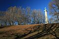
- Parachute Jump
* Ubicación: Coney Island, Coney Island * Fecha de registro: 2 de septiembre de 1980
*

- Parkway Theatre
* Ubicación: 1768 St. John's Pl., Brooklyn * Fecha de registro: 31 de marzo de 2010
- Plymouth Church of the Pilgrims
* Ubicación: 75 Hicks St., Brooklyn Heights * Fecha de registro: 15 de octubre de 1966
*

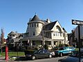
- Prospect Hall
* Ubicación: 263 Prospect Ave., Prospect Heights * Fecha de registro: 15 de abril de 1999
*

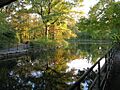
- Prospect Park
* Ubicación: Bordeado por Parkside, Ocean y Flatbush Aves., Prospect Park W. y Prospect SW., Brooklyn * Fecha de registro: 17 de septiembre de 1980
*

- Public Bath No. 7
* Ubicación: 227-231 Fourth Ave., Park Slope * Fecha de registro: 12 de septiembre de 1985
*

- Public School 108
* Ubicación: 200 Lindwood St., Nueva York * Fecha de registro: 10 de diciembre de 1982
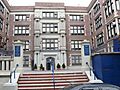
- Public School 111 and Public School 9 Annex
* Ubicación: 249 Sterling Place y 251 Sterling Place, Fort Greene * Fecha de registro: 14 de diciembre de 1981
*

- Public School 39
* Ubicación: 417 6th Ave., Park Slope * Fecha de registro: 17 de abril de 1980
- Public School 65K
* Ubicación: 158 Richmond St., Cypress Hills * Fecha de registro: 10 de diciembre de 1981
- Public School 7
* Ubicación: 131-143 York St., Downtown Brooklyn * Fecha de registro: 3 de noviembre de 1983
- Public School 71K
* Ubicación: 119 Heyward St., Nueva York * Fecha de registro: 4 de noviembre de 1982
*

- Quarters A
* Ubicación: Instalación Naval de EE. UU., Brooklyn Navy Yard * Fecha de registro: 30 de mayo de 1974
*

- Casa John Rankin
* Ubicación: 440 Clinton St., Carroll Gardens * Fecha de registro: 16 de noviembre de 1978
*

- Renaissance Apartments
* Ubicación: 480 Nostrand Ave., Brooklyn * Fecha de registro: 22 de agosto de 1995
- Casa John Roosevelt "Jackie" Robinson
* Ubicación: 5224 Tilden St., East Flatbush * Fecha de registro: 11 de mayo de 1976
*

- Russian Orthodox Cathedral of the Transfiguration of Our Lord
* Ubicación: 228 N. 12th St., Greenpoint * Fecha de registro: 16 de abril de 1980
*

- Casa Saitta
* Ubicación: 1135 84th St., Dyker Heights * Fecha de registro: 30 de mayo de 2007
*

- Shaari Zedek Synagogue
* Ubicación: 767 Putnam Ave., Bedford-Stuyvesant * Fecha de registro: 4 de diciembre de 2009
- South Bushwick Reformed Protestant Dutch Church Complex
* Ubicación: 855-857 Bushwick Ave., South Bushwick * Fecha de registro: 4 de noviembre de 1982
*

- South Congregational Church
* Ubicación: President y Court Sts., South Brooklyn * Fecha de registro: 4 de noviembre de 1982
*

- St. Bartholomew's Protestant Episcopal Church and Rectory
* Ubicación: 1227 Pacific St., Crown Heights * Fecha de registro: 23 de abril de 1980
*

- St. George's Protestant Episcopal Church
* Ubicación: 800 Marcy Ave., Bedford-Stuyvesant * Fecha de registro: 8 de septiembre de 1983
*

- St. Luke's Protestant Episcopal Church
* Ubicación: 520 Clinton Ave., Clinton Hill * Fecha de registro: 16 de septiembre de 1982
- St. Mary's Episcopal Church
* Ubicación: 230 Classon Ave., Clinton Hill * Fecha de registro: 21 de julio de 1983
*

- St. Paul's Protestant Episcopal Church
* Ubicación: 199 Carroll St., South Brooklyn * Fecha de registro: 21 de diciembre de 1989
*

- Casa Stoothoff-Baxter-Kouwenhaven
* Ubicación: 1640 E. 48th St., Flatlands * Fecha de registro: 14 de noviembre de 1982
*

- Temple Beth El of Borough Park
* Ubicación: 4802 15th Ave., Borough Park * Fecha de registro: 27 de abril de 2010
- Twenty third Regiment Armory
* Ubicación: 1322 Bedford Ave., Brooklyn * Fecha de registro: 6 de mayo de 1980
*

- U.S. Army Military Ocean Terminal
* Ubicación: 58th-65th St. y 2nd Ave., Sunset Park * Fecha de registro: 23 de septiembre de 1983
*

- US Post Office-Flatbush Station
* Ubicación: 2273 Church Ave., Flatbush * Fecha de registro: 17 de noviembre de 1988
*

- US Post Office-Kensington
* Ubicación: 421 McDonald Ave., Kensington * Fecha de registro: 17 de noviembre de 1988
*

- US Post Office-Metropolitan Station
* Ubicación: 47 Debevoise St., Williamsburg * Fecha de registro: 17 de noviembre de 1988
- US Post Office-Parkville Station
* Ubicación: 6618 20th Ave., Bensonhurst * Fecha de registro: 17 de noviembre de 1988
*

- Casa Joost Van Nuyse
* Ubicación: 1128 E. 34th St., Flatlands * Fecha de registro: 9 de junio de 2006
- Weir Greenhouse
* Ubicación: 750-751-5th Ave., Sunset Park * Fecha de registro: 10 de mayo de 1984
- Williamsburgh Savings Bank
* Ubicación: 175 Broadway, Williamsburg * Fecha de registro: 9 de abril de 1980
*

- Casa Pieter Wyckoff
* Ubicación: 5902 Canarsie Lane, Flatbush * Fecha de registro: 24 de diciembre de 1967
*

- Wyckoff-Bennett Homestead
* Ubicación: 1669 E. 22nd St., Brooklyn * Fecha de registro: 24 de diciembre de 1974
*

- Young Israel of Flatbush
* Ubicación: 1012 Avenue I, Flatbush * Fecha de registro: 12 de febrero de 2010
Distritos Históricos Importantes
Algunas áreas enteras de Brooklyn son consideradas históricas, lo que significa que muchas de sus calles y edificios juntos cuentan una historia importante.
- Distrito histórico de Albemarle-Kenmore Terraces
* Ubicación: Albemarle Terrace, Kenmore Terrace y E. 21st St., Flatbush * Fecha de registro: 30 de junio de 1983
- Distrito histórico de Boerum Hill
* Ubicación: Bordeado por Pacific, Wyckoff, Bergen, Nevins, Bond y Hoyt Sts., Boerum Hill * Fecha de registro: 26 de septiembre de 1983
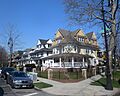
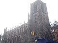
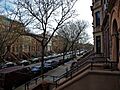
- Distrito histórico de Brooklyn Heights
* Ubicación: Borough de Brooklyn, bordeado por Atlantic Ave., Court y Fulton Sts. y el East River, Brooklyn Heights * Fecha de registro: 15 de octubre de 1966
*

- Distrito histórico de Carroll Gardens
* Ubicación: Carroll y President Sts. entre Smith y Hoyt Sts., Carroll Gardens * Fecha de registro: 26 de septiembre de 1983
- Distrito histórico de Clinton Hill
* Ubicación: Bordeado por Willoughby y Grand Aves., Fulton St. y Vanderbilt Ave., Clinton Hill * Fecha de registro: 19 de junio de 1985
- Distrito histórico de Clinton Hill South
* Ubicación: Aproximadamente Lefferts y Brevoort Pl. entre Washington Ave. y Bedford Pl., Clinton Hill * Fecha de registro: 17 de julio de 1986
- Distrito histórico de Cobble Hill
* Ubicación: Bordeado por Atlantic Ave., Court, Degraw y Hicks Sts., Cobble Hill * Fecha de registro: 11 de junio de 1976
*

- Distrito histórico de Cypress Avenue West
* Ubicación: Bordeado por St. Nicholas y Seneca Aves., Linden y Stockholm Sts., Nueva York * Fecha de registro: 30 de septiembre de 1983
- Distrito histórico de Ditmas Park
* Ubicación: Bordeado por Marlborough Rd., Dorchester, Ocean y Newkirk Aves., Ditmas Park * Fecha de registro: 30 de septiembre de 1983
*

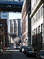
- DUMBO Industrial District
* Ubicación: Bordeado por Main y Washington Sts, East River, John St., Bridge y Jay Sts., y Front y York Sts., DUMBO * Fecha de registro: 22 de septiembre de 2000
*

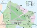
- Distrito histórico de Floyd Bennett Field
* Ubicación: Flatbush Ave., Brooklyn * Fecha de registro: 11 de abril de 1980
*

- Distrito histórico de Fort Greene
* Ubicación: Bordeado por Ft. Greene Pl., Fulton St., Vanderbilt y Myrtle Aves., Fort Greene * Fecha de registro: 26 de septiembre de 1983
*

- Fulton Ferry District
* Ubicación: Bordeado por el East River y Washington, Water, Front y Doughty Sts., Fulton Ferry * Fecha de registro: 28 de junio de 1974
- Distrito histórico de Greenpoint
* Ubicación: Bordeado por Kent, Calyer, Noble y Franklin Sts., Clifford Pl. y Manhattan Ave., Greenpoint * Fecha de registro: 26 de septiembre de 1983
*

- Distrito histórico de Hunterfly Road
* Ubicación: 1698, 1700, 1702, 1704, 1706, 1708 Bergen St., Weeksville * Fecha de registro: 5 de diciembre de 1972
*

- Distrito histórico de Lefferts Manor
* Ubicación: Bordeado por Lincoln Rd., Fenimore St., Rogers Ave. y Flatbush Ave., Prospect Lefferts Gardens * Fecha de registro: 18 de mayo de 1992
*

- Distrito histórico de Park Slope
* Ubicación: Bordeado por Prospect Park West, Berkeley Pl., 15th St., 6th, 7th y Flatbush Aves., Park Slope * Fecha de registro: 21 de noviembre de 1980
*

- Distrito histórico de Pratt Institute
* Ubicación: Bordeado por Hall St., Dekalb Ave., Willoughby St. y Emerson Pl., Clinton Hill * Fecha de registro: 23 de marzo de 2005 *
- Distrito histórico de Prospect Heights
* Ubicación: Bordeado por Pacific y Bergen Sts., Flatbush y Vanderbilt Aves., y Park Pl., Brooklyn * Fecha de registro: 15 de septiembre de 1983
*

- Distrito histórico de Prospect Park South
* Ubicación: Bordeado por BMT RR Tracks, Beverly Rd., y Coney Island y Church Aves., Flatbush * Fecha de registro: 21 de julio de 1983
*

- Distrito histórico de Rockwood Chocolate Factory
* Ubicación: 54-88 Washington, 13-53 Waverly, y 255-275 Park Aves., Fort Greene * Fecha de registro: 6 de octubre de 1983
- Distrito histórico de Senator Street
* Ubicación: 318-370 y 317-347 Senator St., Bay Ridge * Fecha de registro: 10 de octubre de 2002
- State Street Houses
* Ubicación: 291-299, 290-324 State St., Downtown * Fecha de registro: 17 de enero de 1980
- Distrito histórico de Stuyvesant Heights
* Ubicación: Bordeado por Macon, Tompkins, Decatur, Lewis, Chauncey y Stuyvesant, Bedford-Stuyvesant * Fecha de registro: 4 de diciembre de 1975
- Distrito histórico de Sunset Park
* Ubicación: Bordeado por Fourth Ave., Thirty-eighth St., Seventh Ave. y Sixty-fourth St., Sunset Park * Fecha de registro: 15 de septiembre de 1988
*

- Distrito histórico de Wallabout
* Ubicación: 73-83 y 123-141 Cleremont Ave.; 74-148 y 75-143 Clinton Ave.; 381-387, 403-421 y 455-461 Myrtle Ave.; 74-132 y 69-149 Vanderbilt Ave., Wallabout * Fecha de registro: 27 de abril de 2011
- Distrito histórico de Wallabout Industrial
* Ubicación: Clinton, Flushing, Grand, Park, Washington y Waverly Aves., Hall y Ryerson Sts., Wallabout * Fecha de registro: 7 de agosto de 2012
- Distrito histórico de Willoughby-Suydam
* Ubicación: Suydam St., Willoughby, St. Nicholas y Wyckoff Aves., Brooklyn * Fecha de registro: 30 de septiembre de 1983
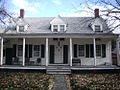
Galería de imágenes
-
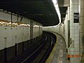
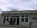
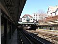
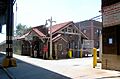
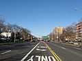
Estación de metro 15th Street – Prospect Park.
-
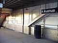
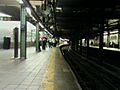
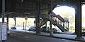
Estación de metro Fourth Avenue.
-
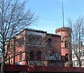
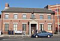
Comisaría y establo del Precinto 68.
-
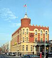
Comisaría y establo del Precinto 83.
-
Estación de metro Ninth Avenue.
-
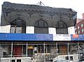
Apartamentos Astral.
-
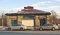
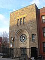
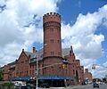
Casa de control de Atlantic Avenue.
-
Estación de metro Atlantic Avenue.
-
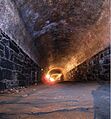
Túnel de Atlantic Avenue.
-
Estación de metro Avenue U.
-
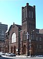
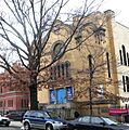
Templo Bautista de Brooklyn.
-
Estación de metro Bay Parkway.
-
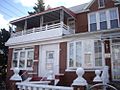
Centro Judío Beth El de Flatbush.
-
Estación de metro Beverley Road.
-

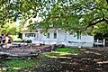
Casa de botes en Prospect Park.
-
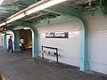
Estación de metro Borough Hall.
-
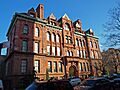
Escuela Secundaria de Varones.
-
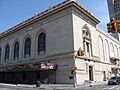
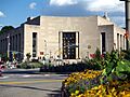
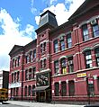
Academia de Música de Brooklyn.
-
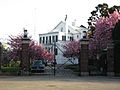
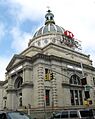
Ayuntamiento de Brooklyn.
-
Puente de Brooklyn.
-
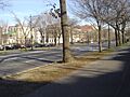
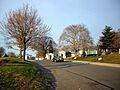
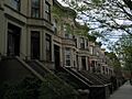
Distrito histórico de Brooklyn Heights.
-
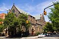
Sociedad Histórica de Brooklyn.
-
Museo de Brooklyn.
-
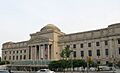
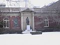
Biblioteca Pública de Brooklyn.
-
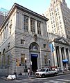
Edificio de la Brooklyn Trust Company.
-
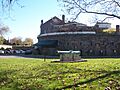
Fuerte Casemate, Cuadrángulo Whiting.
-
Iglesia Luterana Evangélica Inglesa de Cristo.
-
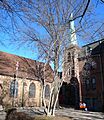
Iglesia de los Santos Inocentes.
-
Distrito histórico de Cobble Hill.
-
Estación de bombeo de la estación de bomberos de Coney Island.
-
Garita del patio de Coney Island.
-
Congregación Tifereth Israel.
-
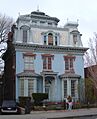
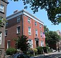
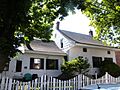
Casa William B. Cronyn.
-
Iglesia Presbiteriana Cuyler.
-
Montaña rusa Cyclone.
-

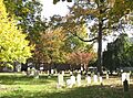
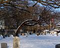
Cementerio Nacional de Cypress Hills.
-
Distrito histórico de Ditmas Park.
-
Distrito Industrial DUMBO.
-
Centro Judío de East Midwood.
-
Eastern Parkway.
-
Armería de la Octava Avenida.
-
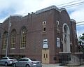
Iglesia Bautista Emmanuel.
-
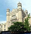
Academia Erasmus Hall.
-
Cementerio Evergreens.
-
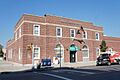
Edificio Federal y Oficina Postal de Brooklyn.
-
Complejo de la Iglesia Reformada Holandesa de Flatbush.
-
Ayuntamiento de Flatbush.
-
Iglesia Reformada Holandesa de Flatlands.
-
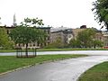
Distrito histórico de Floyd Bennett Field.
-
Distrito histórico de Fort Greene.
-
Casa de Reuniones y Escuela de los Amigos.
-
Restaurante Gage and Tollner.
-
Refugio Griego.
-
Cementerio Green-Wood.
-
Distrito histórico de Greenpoint.
-
Iglesia Adventista del Séptimo Día de Hanson Place.
-
Iglesia de la Santísima Trinidad.
-
Distrito histórico de Hunterfly Road.
-
Banco de Ahorros del Condado de Kings.
-
Sinagoga Kol Israel.
-
Distrito histórico de Lefferts Manor.
-
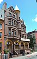
Club Lincoln.
-
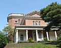
Villa Litchfield.
-
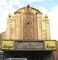
Teatro Loew's Kings.
-
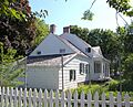
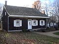
Casa Hendrick I. Lott.
-
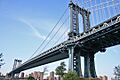
Puente de Manhattan.
-
Parque y Pabellón de Monsignor McGolrick.
-
Iglesia Congregacional de Nueva Inglaterra y Rectoría.
-
Iglesia y Cementerio Reformados de New Lots.
-
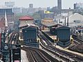
Estación de metro New Utrecht Avenue.
-
Iglesia y Edificios Reformados de New Utrecht.
-
Ocean Parkway.
-
Estación de metro Ocean Parkway.
-
Antigua Sede de Bomberos de Brooklyn.
-
Antigua Primera Iglesia Reformada de Brooklyn.
-
Antiguo Cementerio de Gravesend.
-
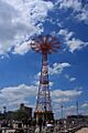
Salto en paracaídas.
-
Distrito histórico de Park Slope.
-
Iglesia Plymouth de los Peregrinos.
-
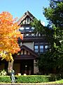
Prospect Hall.
-
Distrito histórico de Prospect Heights.
-
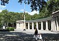
Prospect Park.
-
Distrito histórico de Prospect Park South.
-
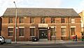
Baño Público No. 7.
-
Escuela Pública 111 y Anexo de la Escuela Pública 9.
-
Escuela Pública 71K.
-
Cuarteles A, Astillero Naval de Brooklyn.
-
Casa John Rankin.
-
Casa de Jackie Robinson.
-
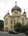
Catedral Ortodoxa Rusa de la Transfiguración de Nuestro Señor.
-
Casa Saitta.
-
Complejo de la Iglesia Protestante Reformada Holandesa de South Bushwick.
-
Iglesia Congregacional del Sur.
-
Iglesia Episcopal Protestante de San Bartolomé y Rectoría.
-
Iglesia Episcopal Protestante de San Jorge.
-
Iglesia Episcopal de Santa María.
-
Iglesia Episcopal Protestante de San Pablo.
-
Casa Stoothoff-Baxter-Kouwenhaven.
-
Distrito histórico de Sunset Park.
-
Armería del Vigésimo Tercer Regimiento.
-
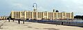
Terminal Militar Oceánica del Ejército de EE. UU.
-
Oficina de Correos de EE. UU. - Estación Flatbush.
-
Oficina de Correos de EE. UU. - Kensington.
-
Oficina de Correos de EE. UU. - Estación Parkville.
-
Banco de Ahorros de Williamsburgh.
-
Estación de metro Wilson Avenue.
-
Casa Pieter Wyckoff.
-
Granja Wyckoff-Bennett.
Véase también
 En inglés: National Register of Historic Places listings in Brooklyn Facts for Kids
