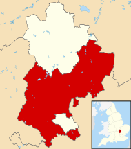
Central Bedfordshire para niños
Datos para niños Central Bedfordshire |
||
|---|---|---|
| Autoridad unitaria | ||
 |
||
| Coordenadas | 52°01′35″N 0°29′26″O / 52.0263, -0.4906 | |
| Capital | Chicksands | |
| Entidad | Autoridad unitaria | |
| • País | ||
| Superficie | ||
| • Total | 715,67 km² | |
| • Total | 274 000 hab. | |
| • Densidad | 382,86 hab./km² | |
| Sitio web oficial | ||
Central Bedfordshire es una autoridad unitaria ubicada en el condado de Bedfordshire, en Inglaterra, Reino Unido. Una autoridad unitaria es un tipo de gobierno local que se encarga de todos los servicios públicos en su área, como la educación, el transporte y la vivienda.
¿Qué es Central Bedfordshire?
Central Bedfordshire es una región que funciona como un solo gobierno local. Esto significa que una única autoridad se encarga de todas las decisiones y servicios para sus habitantes. Es diferente de otras áreas donde los servicios pueden estar divididos entre varios consejos.
Ubicación y Geografía
Esta autoridad unitaria se encuentra en el sureste de Inglaterra. Su capital administrativa es Chicksands. Central Bedfordshire tiene una superficie de aproximadamente 715,67 kilómetros cuadrados. En el año 2015, su población era de alrededor de 274.000 habitantes. Esto significa que tiene una densidad de población de unos 382,86 habitantes por kilómetro cuadrado.
Comunidades Importantes
Central Bedfordshire está formada por muchas ciudades y pueblos. Cada uno de ellos tiene su propia historia y características. Algunas de las localidades más importantes por su tamaño de población son:
- Ampthill 21,407
- Arlesey 6,160
- Barton-le-Clay 5,068
- Beeston 781
- Biggleswade 19,580
- Blunham 1,046
- Broom 639
- Caddington 3,183
- Chalton 557
- Chicksands 1,580
- Clifton 2,524
- Clophill 2,479
- Cranfield 5,870
- Dunstable 32,800
- Dunton 764
- Eaton Bray 4,096
- Everton 530
- Fairfield Park 3,434
- Greenfield / Flitton 1,876
- Harlington 2,320
- Haynes 927
- Heath and Reach 1,466
- Henlow 2,370
- Hockliffe 1,039
- Holywell 647
- Houghton Conquest 1,416
- Houghton Regis 17,829
- Kensworth 1,519
- Langford 3,201
- Leighton Buzzard 41,725
- Lidlington 1,254
- Lower Stondon 4,253
- Marston Moretaine 4,928
- Maulden 2,567
- Meppershall 1,720
- Moggerhanger 617
- Potton 5,134
- Pulloxhill 608
- Sandy 11,856
- Shefford 6,865
- Shillington 1,646
- Silsoe 2,864
- Slip End 1,404
- Stanbridge 737
- Stotfold 8,306
- Streatley 585
- Studham 540
- Tempsford 619
- Toddington 4,675
- Totternhoe 1,039
- Upper Caldecote 1,273
- Upper Gravenhurst 597
- Westoning 2,191
- Woburn 957
- Wrestlingworth 596
Véase también
 En inglés: Central Bedfordshire Facts for Kids

