
Archivo: White, Gallaher & White Mapa de los Estados Unidos de Méjico 1828 UTA

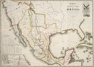
Descripción: On May 21, 1828, less than a month after the new agreement between the U.S. and Mexico, the New York publishing firm of White, Gallaher and White issued this Spanish-language map of Mexico printed by the engraving firm of Vistus Balch and Samuel Stiles. The map simply copied and translated into Spanish Henry S. Tanner's Map of the United States of Mexico, which in turn was based on the southwest portion of Tanner's Map of North America of 1822. In addition to the 1828 edition, White, Gallaher and White's map was issued again sixteen years later, in 1844, to coincide with the growing interest in Texas annexation. The next year, 1845, New York publisher John Disturnell acquired the copper plates and began issuing his own version of the map (without credit to White, Gallaher and White). Disturnell's 1847 edition of this map was later used by both sides in negotiating the 1848 Treaty of Guadalupe Hidalgo that ended the U.S. War with Mexico.
Título: Mapa de los Estados Unidos de Méjico...
Créditos: UTA Libraries Cartographic Connections: map / texto
Autor(a): White, Gallaher & White
Términos de Uso: Dominio Público
Licencia: Dominio Público
¿Se exige la atribución?: No
Usos del archivo
Las siguientes páginas enlazan a este archivo:
