
Archivo: Tectonical map of East Africa
No disponible en mayor resolución.
Tectonical_map_of_East_Africa.png (454 × 382 píxeles; tamaño de archivo: 30 KB; tipo MIME: image/png)
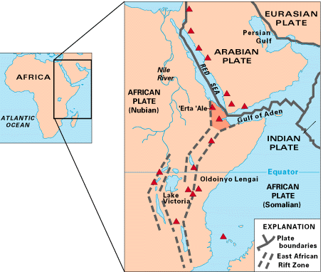
Descripción: Map of East Africa showing some of the historically active volcanoes(red triangles) and the Afar Triangle (shaded, center) -- a so-called triple junction (or triple point), where three plates are pulling away from one another: the Arabian Plate, and the two parts of the African Plate (the Nubian and the Somali) splitting along the East African Rift Zone. The red triangles show historically active volcanoes.
Título: Tectonical map of East Africa
Créditos: http://pubs.usgs.gov/gip/dynamic/East_Africa.html
Autor(a): USGS
Términos de Uso: Dominio Público
Licencia: Dominio Público
¿Se exige la atribución?: No
Usos del archivo
Las siguientes páginas enlazan a este archivo:

Todo el contenido de los artículos de la Enciclopedia Kiddle (incluidas las imágenes) se puede utilizar libremente para fines personales y educativos bajo la licencia Atribución-CompartirIgual a menos que se indique lo contrario.