
Archivo: Map of Oregon highlighting Rogue Valley
No disponible en mayor resolución.
Map_of_Oregon_highlighting_Rogue_Valley.png (300 × 232 píxeles; tamaño de archivo: 24 KB; tipo MIME: image/png)
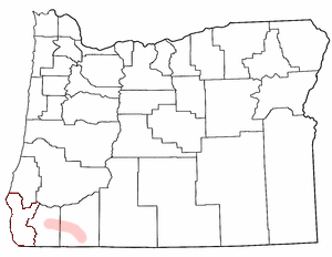
Description: Rogue Valley adapted from Wikipedia county maps by Matthew Trump, 2004 The outline of Curry County is still visible (bits of red.) The image should be cleaned up to clarify that the shaded region in Jackson and Josephine Counties is what's intended to be highlighted.
Title: Map of Oregon highlighting Rogue Valley
Credit: Transferred from en.wikipedia
Author: Original uploader was Decumanus at en.wikipedia
Permission: CC-BY-SA-3.0-MIGRATED; GFDL-WITH-DISCLAIMERS; Released under the GNU Free Documentation License.
Usage Terms: Creative Commons Attribution-Share Alike 3.0
License: CC-BY-SA-3.0
License Link: http://creativecommons.org/licenses/by-sa/3.0/
Attribution Required?: Yes
Usos del archivo
Las siguientes páginas enlazan a este archivo:

Todo el contenido de los artículos de la Enciclopedia Kiddle (incluidas las imágenes) se puede utilizar libremente para fines personales y educativos bajo la licencia Atribución-CompartirIgual a menos que se indique lo contrario.