
Archivo: London Underground Overground DLR Crossrail map

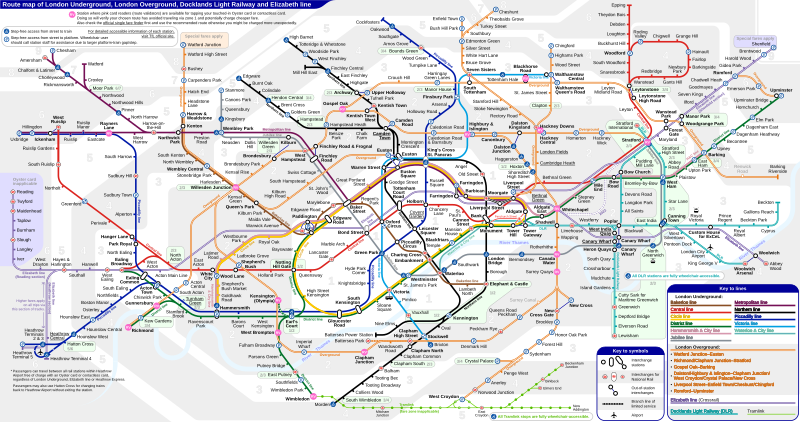
Descripción: *Route map of London Underground, London Overground, Docklands Light Railway and Elizabeth line (Crossrail), including most green-lighted proposals. Out of station interchanges (OSIs) refer to TfL official website and the independent website Oyster and National Rail. Check the pages for details on distance and allotted transfer time of each pair of OSIs. OSIs that share the same name and are within a 0.1-mile walking distance are denoted with a single ring icon without connection line, for the sake of neatness. These include West Hampstead and Shadwell. Paddington, Edgware Road, Euston, Liverpool Street and Canary Wharf stations are exceptions to this rule due to the complicated track alignments between these stations. Temporary OSIs such as Charing Cross-Embankment-Waterloo and same-station-OSI like Woodford are intentionally omitted from this map. The maximum PNG rendering size of this SVG on Wikimedia is 7500 by 3960 px, but use the PDF version if unlimited accurate scaling is desired.Source SVG interactivity (unavailable to PNG render or PDF version)"Show fare zones" button on the upper-left corner. "Show (step-free) accessibility" button on the upper-left corner. By clicking or tapping the line name in the legend or the route path in the line map, that individual route path will blink. This effect can be canceled individually by clicking the line or the line name in the legend once more. Clicking any empty space in the map will cancel the blinking of all lines globally. Popup message on mouse hover (not supported by most mobile devices): Line in route map: Line name Interchange for National Rail icon: nature of the interchange Out of station interchange line: Walking distance and allotted time Camden Town and Covent Garden stations: Limited access West India Quay DLR station: Lack of service from Bank to Lewisham Turnham Green tube station: Piccadilly line trains only stop by at certain time Heathrow Central station: Not to be confused with Heathrow Terminals 2 & 3 station on Piccadilly line
Título: London Underground Overground DLR Crossrail map
Créditos: Trabajo propio
Autor(a): Sameboat
Permiso: Yo, el titular de los derechos de autor de esta obra, la publico en los términos de la siguiente licencia:
Términos de Uso: Creative Commons Attribution-Share Alike 4.0
Licencia: CC BY-SA 4.0
Enlace de Licencia: https://creativecommons.org/licenses/by-sa/4.0
¿Se exige la atribución?: Sí
Usos del archivo
Las siguientes páginas enlazan a este archivo:
