
Archivo: Zheng-He-7th-expedition-map

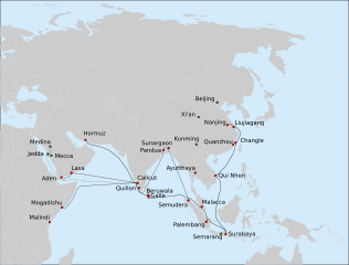
Description: Route of the 7th expedition of Zheng He's fleet (1431-1433). Solid line: the route of the main fleet from Nanjing to Hormuz, as described in Xia Xiyang (下西洋). Dashed line: a possible route of Hong Bao's squadron, to Bengal, Arabia and Africa, based on suggestions made in Dreyer (2007) (who uses Ma Huan's Ying-yai Sheng-lan (瀛涯胜览), Ming shi and other sources.) Dotted line: travel of 7 Chinese explorers, on an Indian (or Arab? vessel) and by caravan from Calicut to Mecca and Medina. Red circles: cities thought to have been visited by the fleets of Zheng He, or the elements of the fleet, on the 7th and/or earlier voyages. Green circles: important places in the biography of Zheng He, and Arabian cities visited by Ma Huan. The main source for all routes: chapter on the last expedition of Zheng He in: Dreyer E. L., Zheng He: China and the Oceans in the Early Ming Dynasty, 1405-1433. — Longman, 2007. — 256 p. — (Library of World Biography Series). — ISBN 0321084438. The cities in Bengal are given as per : Barbosa, Duarte & Dames, Mansel Longworth (1996), An Account Of The Countries Bordering On The Indian Ocean And Their Inhabitants; Written By Duarte Barbosa And Completed About The Year 1518 A.D. Vol I: Including The Coasts Of East Africa, Arabia, Persia And Western India As Far As The Kingdom Of Vijayanagar. Vol. II: Including The Coasts Of Malabar, Eastern India, Further India, China And The Indian Archipelago. Asian Educational Services, pp. 138-139, ISBN 8120604512
Title: Zheng-He-7th-expedition-map
Credit: Own work
Author: Vmenkov, based on the blank map File:Asie.svg (ver. 1) by User:Historicair
Usage Terms: Creative Commons Attribution 1.0
License: CC BY 1.0
License Link: https://creativecommons.org/licenses/by/1.0
Attribution Required?: Yes
Usos del archivo
La siguiente página enlaza a este archivo:
