
Archivo: Western Empire-Europe870
No disponible en mayor resolución.
Western_Empire-Europe870.JPG (428 × 317 píxeles; tamaño de archivo: 83 KB; tipo MIME: image/jpeg)
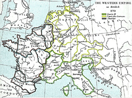
Description: Frank king Charlemagne's kingdom survived the leader and covered much of Western Europe from 795 until 843 when a treaty split it amongst his grandsons: Central Franks ruled by w:Lothar I (green), East Franks ruled by w:Louis the German (yellow), and w:Charles the Bald led West Franks (purple). This particular map is from the Atlas to Freeman's Historical Geography, edited by J.B. Bury, Longmans Green and Co. Third Edition 1903. It is in the public domain and you may download it or print it for any use.
Title: Western Empire-Europe870
Usage Terms: Public domain
License: Public domain
Attribution Required?: No
Usos del archivo
La siguiente página enlaza a este archivo:

Todo el contenido de los artículos de la Enciclopedia Kiddle (incluidas las imágenes) se puede utilizar libremente para fines personales y educativos bajo la licencia Atribución-CompartirIgual a menos que se indique lo contrario.