
Archivo: Wabash and Erie Canal map
No disponible en mayor resolución.
Wabash_and_Erie_Canal_map.jpg (334 × 550 píxeles; tamaño de archivo: 66 KB; tipo MIME: image/jpeg)
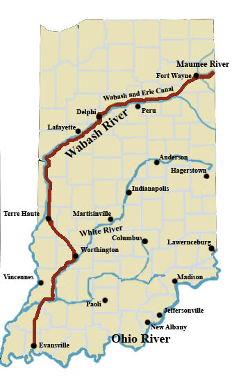
Description: A map of Indiana showing the course of the Wabash and Erie Canal. Lines are approximate
Title: Wabash and Erie Canal map
Credit: Own work
Author: Charles Edward
Permission: I, the copyright holder of this work, release this work into the public domain. This applies worldwide. In some countries this may not be legally possible; if so: I grant anyone the right to use this work for any purpose, without any conditions, unless such conditions are required by law.
Usage Terms: Public domain
License: Public domain
Attribution Required?: No
Usos del archivo
La siguiente página enlaza a este archivo:

Todo el contenido de los artículos de la Enciclopedia Kiddle (incluidas las imágenes) se puede utilizar libremente para fines personales y educativos bajo la licencia Atribución-CompartirIgual a menos que se indique lo contrario.