
Archivo: Vercors topographic map-fr

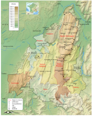
Descripción: Topographic map in French of Vercors
Título: Vercors topographic map-fr
Créditos: Own work and Sémhur for the topography; Topographic data from the NASA Shuttle Radar Topography Mission (SRTM3 v.2) (public domain) edited with 3DEM and dlgv32 Pro and vectorized with Inkscape ; Note : The shaded relief is a raster image embedded in the SVG file. Additional datas: Nature regional reserve park of Vercors; Wikimapia Géoportail France fr:Vercors
Autor(a): (Ewan ar Born - fr:Ewan ar Born)
Permiso: GFDL / Attribution and Share-Alike required
Términos de Uso: Creative Commons Attribution-Share Alike 4.0
Licencia: CC BY-SA 4.0
Enlace de Licencia: https://creativecommons.org/licenses/by-sa/4.0
¿Se exige la atribución?: Sí
Usos del archivo
La siguiente página enlaza a este archivo:
