
Archivo: United Kingdom EU referendum 2016 area results

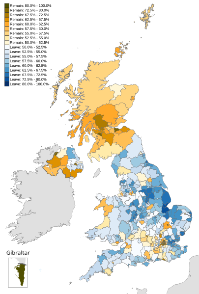
Description: Map of the United Kingdom showing the voting areas for the European Union membership referendum, 2016. Areas marked in blue show a majority of votes in favour of leaving the European Union, while areas marked in yellow show a majority in favour of remaining a member.
Title: United Kingdom EU referendum 2016 area results
Credit: This vector image includes elements that have been taken or adapted from this file: Scottish council areas 2011.svg (by Nilfanion). This vector image includes elements that have been taken or adapted from this file: United Kingdom AV referendum area results.svg (by Nilfanion). This vector image includes elements that have been taken or adapted from this file: Wales, administrative divisions - de - monochrome.svg (by TUBS). This vector image includes elements that have been taken or adapted from this file: Gibraltar locator map.svg (by Sting). This vector image includes elements that have been taken or adapted from this file: 2010UKElectionMap.svg.
Author: Mirrorme22 Brythones Nilfanion: English and Scottish council areas TUBS: Welsh council areas Sting: Gibraltar
Usage Terms: Creative Commons Attribution-Share Alike 3.0
License: CC BY-SA 3.0
License Link: https://creativecommons.org/licenses/by-sa/3.0
Attribution Required?: Yes
Usos del archivo
La siguiente página enlaza a este archivo:
