
Archivo: ThreeGorgesDam-Landsat7

Tamaño de esta previsualización: 459 × 599 píxeles. Otras resoluciones: 184 × 240 píxeles | 540 × 705 píxeles.
Archivo original (540 × 705 píxeles; tamaño de archivo: 197 KB; tipo MIME: image/jpeg)
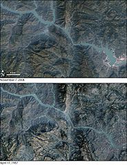
Description: These images show the Yangtze River in the vicinity of the Three Gorges Dam (lower right). Landsat 7 acquired the top image on November 7, 2006, after the main wall was complete. Landsat 5 acquired the bottom image on April 17, 1987. The lower image has been recolored to more closely match the colors of the upper one.
Title: ThreeGorgesDam-Landsat7
Credit: Transferred from en.wikipedia to Commons by Rehman using CommonsHelper.
Author: The original uploader was Sagredo at English Wikipedia
Usage Terms: Public domain
License: Public domain
Attribution Required?: No
Usos del archivo
Las siguientes páginas enlazan a este archivo:

Todo el contenido de los artículos de la Enciclopedia Kiddle (incluidas las imágenes) se puede utilizar libremente para fines personales y educativos bajo la licencia Atribución-CompartirIgual a menos que se indique lo contrario.