
Archivo: Tenerife, Canary Islands ESA23970088

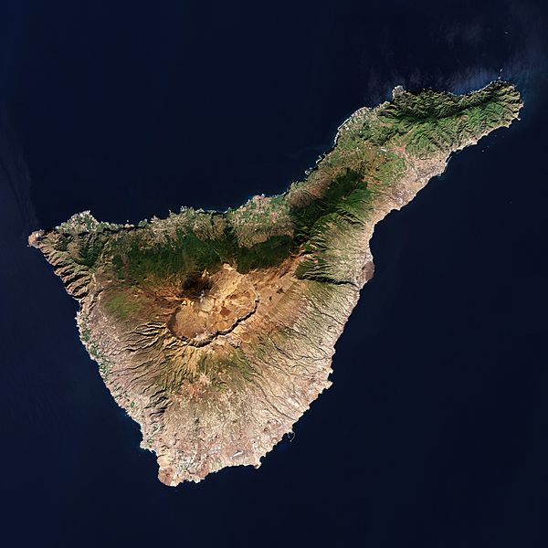
Descripción: The Copernicus Sentinel-2 mission takes us over Tenerife – the largest of Spain’s Canary Islands. Zoom in to see this image at its full 10 m resolution or click on the circles to learn more about the features in it. Located in the Atlantic Ocean, opposite the northwest coast of Africa, the Canary Islands consist of eight main islands including Gran Canaria, Lanzarote and La Palma, as well as many small islands and islets. Teide National Park, located in the centre of the island, is a UNESCO World Heritage Site and includes Mount Teide which dominates the island. Standing at around 3718 m, its summit is the highest point on Spanish soil. However, much of the volcano’s height is hidden. If measured from the ocean floor, its height of 7500 m makes Teide the third-highest volcano in the world. Teide is an active volcano: its most recent eruption occurred in 1909 when a lava flow buried much of the town and harbour of Garachico on the northern coast. Owing to the island’s diverse topography and unique climatic factors, Tenerife has multiple microclimates, which means that the weather can vary drastically from one part of the island to the other. Weather and climate are heavily influenced by the trade winds blowing from the northeast for most of the year, bringing humidity and precipitation to the north of the island, as well as to the northern slopes of Mount Teide. This effect can be clearly seen in the dark green colours in the image showing vegetation cover. This band of green generally follows the boundary of Corona Forestal Natural Park, which covers a total area of 46 000 hectares. Most of Tenerife’s inhabitants live on the lower slopes, within a few kilometres of the sea. Around half the population is in or near the cosmopolitan capital of Santa Cruz de Tenerife, on the narrower northeast part of the island, and San Cristóbal de la Laguna, the former capital. Other inhabitants live on the intensively cultivated slopes near the northern coast, where the chief towns are La Orotava, Los Realejos, and Puerto de la Cruz. The south is a popular destination where holidaymakers enjoy time on the beautiful beaches of Costa Adeje. Tenerife is home to Teide Observatory, located around 10 km from Santa Cruz de Tenerife on the Izaña mountain, which is home to ESA’s IZN-1 laser ranging station – the first laser ranging station to be made commercially available. It is here where lasers are aimed into Earth’s skies, seeking out satellites and soon pieces of space rubbish, as well as measuring their positions and trajectories to prevent catastrophic collisions. The station, telescope and laser have recently undergone months of testing and commissioning and have passed their final tests with flying colours. Read more about ESA’s laser ranging station. This image, captured on 31 December 2021, is also featured on the Earth from Space video programme.
Título: Tenerife, Canary Islands ESA23970088
Créditos: Tenerife, Canary Islands
Autor(a): European Space Agency
Términos de Uso: Creative Commons Attribution-Share Alike 3.0 igo
Licencia: CC BY-SA 3.0 igo
Enlace de Licencia: https://creativecommons.org/licenses/by-sa/3.0/igo/deed.en
¿Se exige la atribución?: Sí
Usos del archivo
La siguiente página enlaza a este archivo:
