
Archivo: Tanggu Truce Map

Tamaño de esta previsualización: 794 × 600 píxeles. Otras resoluciones: 318 × 240 píxeles | 1985 × 1500 píxeles.
Archivo original (1985 × 1500 píxeles; tamaño de archivo: 403 KB; tipo MIME: image/jpeg)
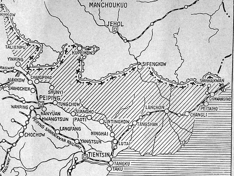
Description: The shaded part of this map shows the areas demilitarized by the Tanggu Truce. Note also that the remainder of the Hebei Province, including Beijing and Tianjin, would also be demilitarized of Nationalist forces under the terms of the He-Umezu Agreement, but independent warlords like Song Zheyuan continued to operate there.
Title: Tanggu Truce Map
Credit: a pamphlet called "Sino-Japanese Conflict Elucidated"
Author: Canadian Japanese Association
Usage Terms: Public domain
License: Public domain
Attribution Required?: No
Usos del archivo
La siguiente página enlaza a este archivo:

Todo el contenido de los artículos de la Enciclopedia Kiddle (incluidas las imágenes) se puede utilizar libremente para fines personales y educativos bajo la licencia Atribución-CompartirIgual a menos que se indique lo contrario.