
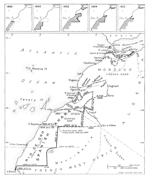
Archivo: Spanish territorial boundary changes in Northwest Africa 1885-1912

Tamaño de esta previsualización: 495 × 600 píxeles. Otras resoluciones: 198 × 240 píxeles | 1724 × 2089 píxeles.
Archivo original (1724 × 2089 píxeles; tamaño de archivo: 142 KB; tipo MIME: image/png)
Descripción: Map showing Spanish territorial expansion and contraction in Morocco and the Western Sahara from the late 19th century to the Franco-Spanish convention of 1912, which definitely settled the boundary issue and provided for the creation of the Spanish protectorate in Morocco.
Título: Spanish territorial boundary changes in Northwest Africa 1885-1912
Créditos: Geographical Review (US)
Autor(a): Geographical Review (US)
Términos de Uso: Dominio Público
Licencia: Dominio Público
¿Se exige la atribución?: No
Usos del archivo
Las siguientes páginas enlazan a este archivo:

Todo el contenido de los artículos de la Enciclopedia Kiddle (incluidas las imágenes) se puede utilizar libremente para fines personales y educativos bajo la licencia Atribución-CompartirIgual a menos que se indique lo contrario.