
Archivo: South Africa 2011 Coloured population proportion map

Tamaño de esta previsualización PNG del archivo SVG: 684 × 599 píxeles. Otra resolución: 274 × 240 píxeles.
Archivo original (archivo SVG, nominalmente 809 × 709 píxeles, tamaño de archivo: 730 KB)
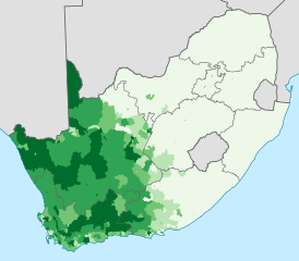
Description: Map showing the proportion of the South African population that self-described as "Coloured" in the 2011 census, at electoral ward level. 0–20% 20–40% 40–60% 60–80% 80–100% Projection is Albers Equal-Area Conic, with standard parallels at 25.5° S and 31.5° S, and origin at 28.5° S 25.5° E.
Title: South Africa 2011 Coloured population proportion map
Credit: Statistics South Africa's Census 2011 is the source of the basic population data. The map results from my own processing of the data. For ward boundaries see File:South Africa electoral wards 2011 blank.svg.
Author: Htonl
Usage Terms: Public domain
License: Public domain
Attribution Required?: No
Usos del archivo
La siguiente página enlaza a este archivo:

Todo el contenido de los artículos de la Enciclopedia Kiddle (incluidas las imágenes) se puede utilizar libremente para fines personales y educativos bajo la licencia Atribución-CompartirIgual a menos que se indique lo contrario.