
Archivo: Smithsonian miscellaneous collections (1921) (14781989791)
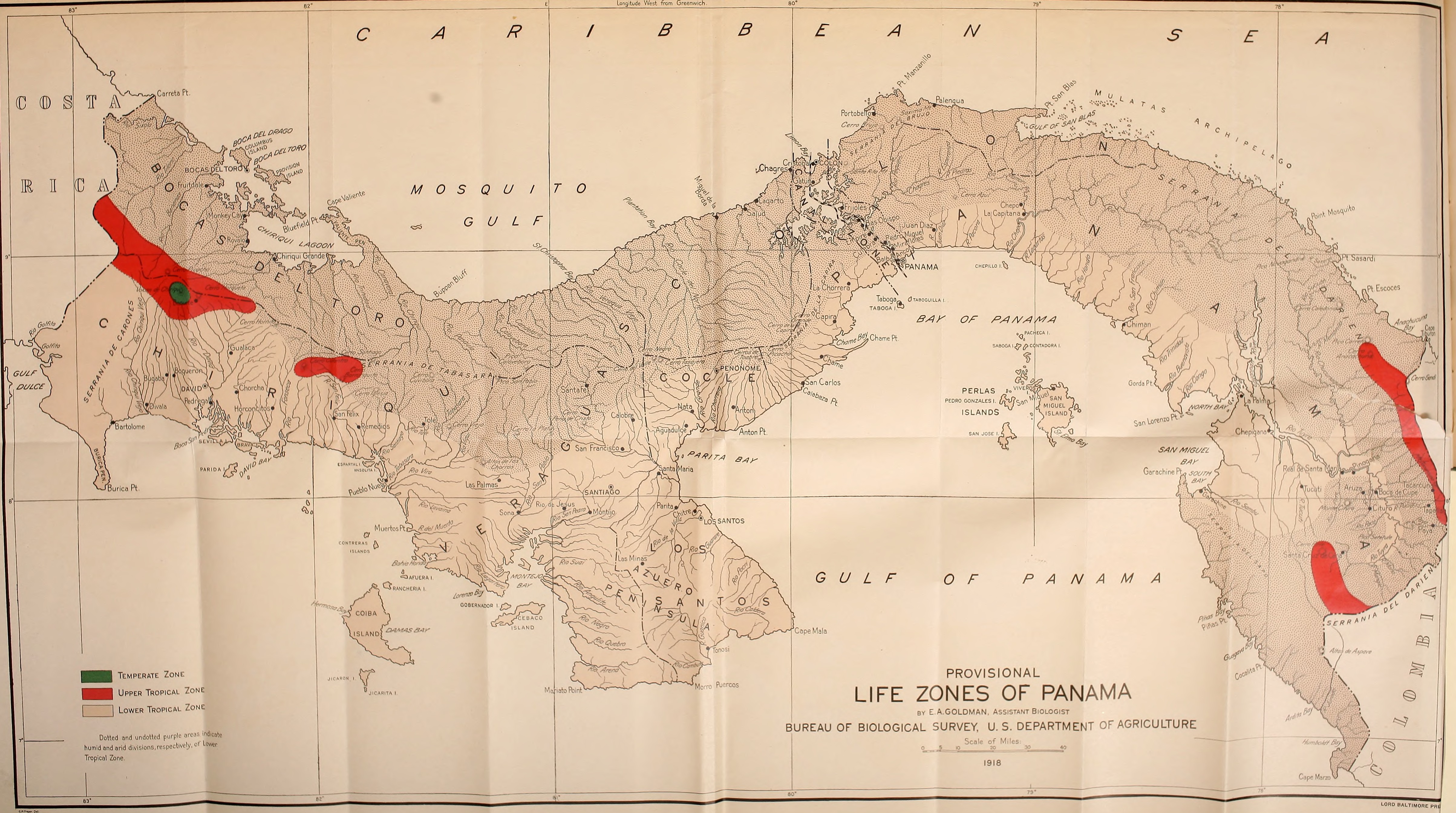
Descripción: Identifier: smithsonianmisce691921smit (find matches) Title: Smithsonian miscellaneous collections Year: 1862 (1860s) Authors: Smithsonian Institution Subjects: Science Publisher: Washington : Smithsonian Institution Contributing Library: Smithsonian Libraries Digitizing Sponsor: Smithsonian Libraries View Book Page: Book Viewer About This Book: Catalog Entry View All Images: All Images From Book Click here to view book online to see this illustration in context in a browseable online version of this book. Text Appearing Before Image: 34 Savanna area and semi-forested savanna borders 36 Upper Tropical Zone 38 Temperate Zone 41 List of the mammals 42 General account of the mammals 44 Bibliography 23$ Index 267 ILLUSTRATIONSPLATES PLATE PAGE i. Map of Panama showing life zones Frontispiece 2. Fig. 1.—Camp on Cerro Azul. Fig. 2.—Field party resting on slope of Cerro Azul 4 3. Fig. 1.—Rio Indio, a small tidal tributary of the Rio Chagres near Gatun, Canal Zone. Fig. 2.—Tidal forest along lower course ofRio Chagres 5 4. Fig. 1.—Forest along lower course of Rio Chagres, Canal Zone. Fig. 2.—Forest, extensively invaded by tide, along lower course ofRio Tuyra 6 5. Fig. 1.—Tidal forest, largely mangroves, near Porto Bello. Fig. 2.— Tidal forest interior near Porto Bello 7 6. Fig. 1.—Old line of Panama Railroad, abandoned and nearly sub- merged by rising waters of Gatun Lake. Fig. 2.—Gatun Lake withwater rising 8 Smithsonian Miscellaneous Collections, Vol. 69, No. 5 1 V1ITHS0NIAN MISCELLANEOUS COLLECTIONS Text Appearing After Image: BALTIMORE PH0 2 SMITHSONIAN MISCELLANEOUS COLLECTIONS VOL. 69 PLATE PAGE 7. Fig. I.—Destruction of forest by rising waters of G3tun Lake. Fig. 2.—Destruction of forest by rising waters of Gatun Lake 9 8. Fig. 1.—Rio Tuyra at Boca de Cupe. Fig. 2.—Rio Cascajal near Porto Bello 10 9. Fig. 1.—Cuipo tree (Cavanillesia platanifolia). Fig. 2.—Base of Cuipo tree showing characteristic buttresses 11 10. Fig. I.—Cana, eastern Panama, showing adjacent forested slopes. Fig. 2.—Cana, eastern Panama. Looking east across Cana Valley.. 14 11. Fig. 1.—Humid Lower Tropical Zone near Cana. Fig. 2.—Humid Lower Tropical Zone forest interior at 300 feet altitude on northernbasal slope of Mount Pirre 15 12. Fig. 1.—Arid Lower Tropical Zone near southern base of Cerro Azul. Fig. 2.—Humid Lower Tropical Zone near summit of Cerro Azul. 26 13. Fig. 1.—Humid Lower Tropical Zone. An aquatic environment in the lower Chagres Valley near Bohio. Fig. 2.—Humid Lower TropicalZone. Typical s Note About Images Please note that these images are extracted from scanned page images that may have been digitally enhanced for readability - coloration and appearance of these illustrations may not perfectly resemble the original work.
Título: Smithsonian miscellaneous collections (1921) (14781989791)
Créditos: https://www.flickr.com/photos/internetarchivebookimages/14781989791/ Source book page: https://archive.org/stream/smithsonianmisce691921smit/smithsonianmisce691921smit#page/n477/mode/1up
Autor(a): Internet Archive Book Images
Permiso: At the time of upload, the image license was automatically confirmed using the Flickr API. For more information see Flickr API detail.
Términos de Uso: No known copyright restrictions
Licencia: No restrictions
Enlace de Licencia: https://www.flickr.com/commons/usage/
¿Se exige la atribución?: No
Usos del archivo
La siguiente página enlaza a este archivo:
_(14781989791).jpg&oldid=3664540)

_(14781989791).jpg)