
Archivo: Satellite image of Madagascar in September 2003

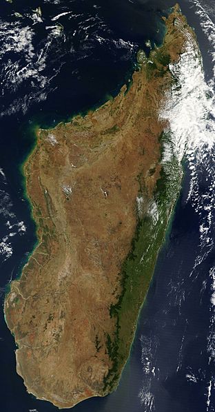
Descripción: Satellite image of Madagascar in September 2003. Slightly cropped, original taken from NASA's Visible Earth: [1]. Original description: The world's fourth largest island, Madagascar, is featured in this Moderate Resolution Imaging Spectroradiometer (MODIS) image taken by the Terra satellite on September 10, 2003. Several active fires, marked with red dots, burn in the central highlands, which are primarily covered with rice fields. The fires are probably controlled burns to clear farmland. The narrow strip of green along the east coast of the island is a rain forest. The west coast is lined with baobabs, a desert tree with a fat trunk, and thorny forest.
Título: Satellite image of Madagascar in September 2003
Créditos: http://visibleearth.nasa.gov/view_rec.php?id=5769
Autor(a): DesconocidoUnknown author
Términos de Uso: Dominio Público
Licencia: Dominio Público
¿Se exige la atribución?: No
Usos del archivo
La siguiente página enlaza a este archivo:
