
Archivo: Saharan topographic elements map

Tamaño de esta previsualización: 800 × 395 píxeles. Otras resoluciones: 320 × 158 píxeles | 1396 × 690 píxeles.
Archivo original (1396 × 690 píxeles; tamaño de archivo: 757 KB; tipo MIME: image/png)
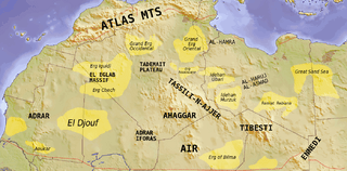
Description: Map showing major Dune seas (ergs) and Mountain ranges of the Sahara. Red dashed line shows approximate limit of the Sahara. National borders in grey. Dune seas in yellow. Derived from Blank map Image:Africa_topography_map_with_borders.png. Data taken from http://www.sahara-overland.com image of Michlein Map and Geology.com's Sahara Desert Map.
Title: Saharan topographic elements map
Credit: Own work by uploader Derived from Blank map Image:Africa_topography_map_with_borders.png
Author: T L Miles
Usage Terms: Creative Commons Attribution-Share Alike 3.0
License: CC BY-SA 3.0
License Link: http://creativecommons.org/licenses/by-sa/3.0
Attribution Required?: Yes
Usos del archivo
La siguiente página enlaza a este archivo:

Todo el contenido de los artículos de la Enciclopedia Kiddle (incluidas las imágenes) se puede utilizar libremente para fines personales y educativos bajo la licencia Atribución-CompartirIgual a menos que se indique lo contrario.