
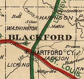
Archivo: RR Map of Blackford County 1890s
No disponible en mayor resolución.
RR_Map_of_Blackford_County_1890s.jpg (275 × 258 píxeles; tamaño de archivo: 26 KB; tipo MIME: image/jpeg)
Description: This is the Blackford County portion of an 1896 map created by the Indiana State Board of Tax Commissioners and on file in the Library of Congress
Title: RR Map of Blackford County 1890s
Credit: Library of Congress Geography and Map Division Washington, D.C. (United States--Indiana. [1896?])
Author: Indiana State Board of Tax Commissioners
Permission: public use
Usage Terms: Public domain
License: Public domain
Attribution Required?: No
Usos del archivo
La siguiente página enlaza a este archivo:

Todo el contenido de los artículos de la Enciclopedia Kiddle (incluidas las imágenes) se puede utilizar libremente para fines personales y educativos bajo la licencia Atribución-CompartirIgual a menos que se indique lo contrario.