
Archivo: PigWar-boundaries

Tamaño de esta previsualización: 742 × 600 píxeles. Otras resoluciones: 297 × 240 píxeles | 1058 × 855 píxeles.
Archivo original (1058 × 855 píxeles; tamaño de archivo: 637 KB; tipo MIME: image/png)
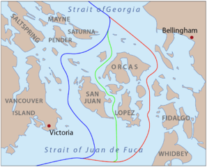
Description: This is a map of the proposed boundaries between the United States and Canada around the San Juan Islands, for use in describing the Pig War. I, Pfly, made it with ArcGIS, Adobe Illustrator, and Adobe Photoshop.
Title: PigWar-boundaries
Credit: self-made, information one boundaries from Hayes, Derek, Historical Atlas of the Pacific Northwest.
Author: Pfly
Usage Terms: Creative Commons Attribution-Share Alike 3.0
License: CC BY-SA 3.0
License Link: https://creativecommons.org/licenses/by-sa/3.0
Attribution Required?: Yes
Usos del archivo
La siguiente página enlaza a este archivo:

Todo el contenido de los artículos de la Enciclopedia Kiddle (incluidas las imágenes) se puede utilizar libremente para fines personales y educativos bajo la licencia Atribución-CompartirIgual a menos que se indique lo contrario.