
Archivo: Partition of Hungary
No disponible en mayor resolución.
Partition_of_Hungary.png (389 × 328 píxeles; tamaño de archivo: 13 KB; tipo MIME: image/png)
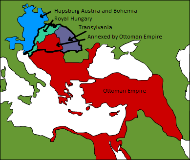
Descripción: A map displaying position of the Kingdom of Hungary before 1526, and the 3 parts into which it was divided after the Battle of Mohács: Royal Hungary, Transylvania, and the part that was annexed by the Ottoman Empire. en:Category:Maps of the history of Hungary
Título: Partition of Hungary
Créditos: Transferido desde en.wikipedia a Commons.
Autor(a): Esoltas de Wikipedia en inglés Later versions were uploaded by PANONIAN, DonatusHR at en.wikipedia.
Términos de Uso: Dominio Público
Licencia: Dominio Público
¿Se exige la atribución?: No
Usos del archivo
La siguiente página enlaza a este archivo:

Todo el contenido de los artículos de la Enciclopedia Kiddle (incluidas las imágenes) se puede utilizar libremente para fines personales y educativos bajo la licencia Atribución-CompartirIgual a menos que se indique lo contrario.