
Archivo: Oregon Country map-fr

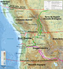
Descripción: Map showing Oregon Country and disputed area in 1818 - 1846.
Título: Oregon Country map-fr
Créditos: Own work with data from File:Oregoncountry.png by User:Kmusser; Coast : NASA Shuttle Radar Topography Mission (SRTM3 v.2) (public domain) edited with 3DEM, vectorized with Inkscape ; Rivers : USGS Hydro1K édited with Quantum GIS Topography and bathymetry : NGDC ETOPO1 edited with Global Mapper 9 (dlgv32pro limited edition), de l'United States Geological Survey (USGS); Cities, roads, lakes : Demis add-on for World Wind (see the approval e-mail and the Demis forum) ; Scale symbol : Image:Scale_kilometres_miles_svg.svg de Sémhur, under "Public domain" Locator map from File:United States (orthographic projection).svg Others symbols from File:Maps template-fr.svg Equidistant conic Albers projection ; WGS84 datum ; Note : The relief is a raster image embedded in the SVG file.
Autor(a): Bourrichon - fr:Bourrichon
Permiso: Yo, el titular de los derechos de autor de esta obra, la publico en los términos de la siguiente licencia:
Términos de Uso: Creative Commons Attribution-Share Alike 3.0
Licencia: CC BY-SA 3.0
Enlace de Licencia: https://creativecommons.org/licenses/by-sa/3.0
¿Se exige la atribución?: Sí
Usos del archivo
La siguiente página enlaza a este archivo:
