
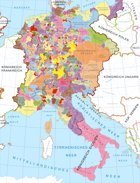
Archivo: Mitteleuropa zur Zeit der Staufer

Descripción: A map in German of central Europe during the time of the Hohenstaufen Emperors, primarily showing the territories of the Holy Roman Empire and the Kingdom of Sicily. The map is a vectorised version of this map from Professor G. Droysens Allgemeiner Historischer Handatlas, which was published in 1886 by R[ichard] Andree. I will at some point create an English version. Changes from source image: The small map in the top left corner (Die Welfenlande z. Zeit Heinrich d. Löwen – "Welf lands at the time of Henry the Lion") has not been included. The legend in the bottom left corner has not been included since it is redundant with this description and/or image captions. As such, both England and North Africa have been expanded into the areas which the map and legend cover. The Balearic Islands were added; for some reason, Droysen's map omitted them. Names of rivers have not (yet?) been included. Locations of cities, fortresses etc have not been included. Cöln has been changed to its modern spelling of Köln. Some notes on territory changes have been added (Corfu, La Bresse), Key: Imperial and Hohenstaufen territory. Ecclesiastical territories (Papal States, territory of the Teutonic Order, Prince-(Arch)bishoprics and abbeys). Border of the Holy Roman Empire Borders of the constituent kingdoms of the Holy Roman Empire (Kingdom of Germany, Burgundy/Arles, and Italy). .mw-parser-output .div-col{margin-top:.3em;column-width:30em}.mw-parser-output .div-col-small{font-size:90%}.mw-parser-output .div-col-rules{column-rule:1px solid #aaa}.mw-parser-output .div-col dl,.mw-parser-output .div-col ol,.mw-parser-output .div-col ul{margin-top:0}.mw-parser-output .div-col li,.mw-parser-output .div-col dd{page-break-inside:avoid;break-inside:avoid-column} Select translations: Baiern Bavaria (modern German spelling Bayern) Böhmen Bohemia Braunschweig Brunswick Deutschordensgebiet Territory of the German/Teutonic Order Kärnten Carinthia Kirchenstaat Papal States Köln Cologne Krain Carniola Lützelburg Luxembourg (modern German Luxemburg) Mähren Moravia Meer Sea Österreich Austria Pommern Pomerania Schlesien Silesia Abbreviations: A. Abtei Abbey BGFT. Burggrafschaft Burgraviate BM. Bistum Bishopric EBM. ERZBM. Erzbistum Archbishopric FSM. Fürstentum Principality GFT. Grafschaft County HFT. Herrschaft Lordship HZM. Herzogtum Duchy KGR. Königreich Kingdom LANDGFT. LGFT. Landgrafschaft Landgraviate MARKGFT. MGFT. Markgrafschaft Margraviate PGFT. PFALZGFT. Pfalzgrafschaft County Palatine/Palatinate
Título: Mitteleuropa zur Zeit der Staufer
Créditos: File: own work Data: File:Droysens-26.jpg
Autor(a): Alphathon /'æɫfə.θɒn/
Términos de Uso: Creative Commons Attribution-Share Alike 4.0
Licencia: CC BY-SA 4.0
Enlace de Licencia: https://creativecommons.org/licenses/by-sa/4.0
¿Se exige la atribución?: Sí
Usos del archivo
La siguiente página enlaza a este archivo:
