
Archivo: Mecklenburg-Vorpommern Map Districts Border Mecklenburg Western Pomerania - Landkreise Grenzen Karte MV MeckPomm

Tamaño de esta previsualización PNG del archivo SVG: 800 × 549 píxeles. Otra resolución: 320 × 220 píxeles.
Archivo original (archivo SVG, nominalmente 1129 × 775 píxeles, tamaño de archivo: 759 KB)
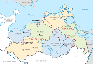
Description: Locator map of counties and their seats in Mecklenburg-Vorpommern, Germany after county reorganization 2011. The red-white line indicates the former border between the state of Mecklenburg and the Prussian province of Pommerania.
Title: Mecklenburg-Vorpommern Map Districts Border Mecklenburg Western Pomerania - Landkreise Grenzen Karte MV MeckPomm
Credit: File:Mecklenburg-Vorpommern districts 2011 colored labeled Meck-Pomm-border.svg
Author: TUBS
Usage Terms: Public domain
License: Public domain
Attribution Required?: No
Usos del archivo
La siguiente página enlaza a este archivo:

Todo el contenido de los artículos de la Enciclopedia Kiddle (incluidas las imágenes) se puede utilizar libremente para fines personales y educativos bajo la licencia Atribución-CompartirIgual a menos que se indique lo contrario.