
Archivo: Mauna Kea and Kohala Volcanic Hazard Mapping
No disponible en mayor resolución.
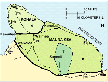
Mauna_Kea_and_Kohala_Volcanic_Hazard_Mapping.gif (354 × 269 píxeles; tamaño de archivo: 25 KB; tipo MIME: image/gif)
Descripción: Threat mapping of Kohala and of Mauna Kea, on a scale of 1 to 9 with 1 being most dangerous (certain areas of Kilauea) and 9 (Kohala) the least.
Título: Mauna Kea and Kohala Volcanic Hazard Mapping
Créditos: root usage
Autor(a): USGS
Permiso: Work of the United States Geological Service, a branch of the U.S. Government, therefore in the public domain.
Términos de Uso: Dominio Público
Licencia: Dominio Público
¿Se exige la atribución?: No
Usos del archivo
La siguiente página enlaza a este archivo:

Todo el contenido de los artículos de la Enciclopedia Kiddle (incluidas las imágenes) se puede utilizar libremente para fines personales y educativos bajo la licencia Atribución-CompartirIgual a menos que se indique lo contrario.