
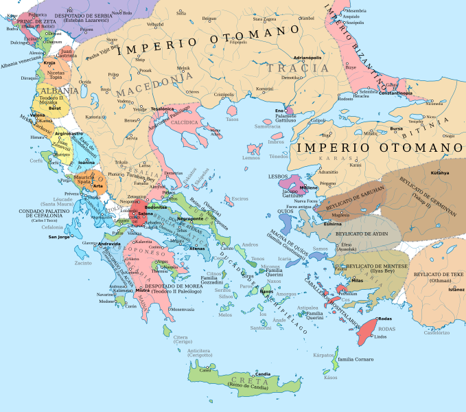
Archivo: Map of the southern Balkans, 1410-es

Descripción: Political map of the southern Balkans and western Anatolia in 1410. Disclaimer: The borders shown are often uncertain and conjectural; an effort has been made to be as accurate as possible and follow the relevant scholarship, but errors or omissions may still be present. Any help in correcting and/or improving this work would be greatly appreciated. Sources: Basic map sources: John Haldon, Palgrave Atlas of Byzantine History, various maps Hugh Kennedy, Historical Atlas of Islam, Map 11.3 "Byzantium’s Balkan neighbours 1350-1453: Serbs, Bulgars and Turks." Hugh Kennedy, '"Atlas to Freeman's Historical Geography, Map of south-eastern Europe in 1401 ADSouthern Greece and Latin states in the Aegean and the Balkans: Miller, William (1908) The Latins in the Levant, a History of Frankish Greece (1204–1566), Category:New York: E.P. Dutton and Company Setton, Kenneth M. (1976) The Papacy and the Levant (1204–1571), Volume I: The Thirteenth and Fourteenth Centuries, Filadelfia: The American Philosophical Society ISBN: 0-87169-114-0.Epirus, Albania, Montenegro: Nicol, Donald M. (1984) The Despotate of Epiros 1267-1479: A Contribution to the History of Greece in the Middle Ages, Cambridge University Press ISBN: 9780521261906. Brendan Osswald, L'Epire du treizième au quinzième siècle: autonomie et hétérogénéité d'une région balkanique Fine, John Van Antwerp (1994) The Late Medieval Balkans: A Critical Survey from the Late Twelfth Century to the Ottoman Conquest, Ann Arbor: University of Michigan Press ISBN: 978-0-472-08260-5.Northern Greece: Vacalopoulos, Apostolos E. (1973) History of Macedonia 1354–1833, Salónica: Institute for Balkan Studies OCLC: 220583971.Boundaries of the Byzantine Empire: Bakalopulos, A. (1962). "Les limites de l'empire byzantin depuis la fin du XIV' siècle jusqu'à sa chute (1453)". Byzantinische Zeitschrift 55 (1): 56–65. DOI:10.1515/byzs.1962.55.1.56. Dennis, George T. (1967). "The Byzantine–Turkish Treaty of 1403". Orientalia Christiana Periodica XXXIII: 72–88.Ottoman Empire and Anatolian beyliks: Kastritsis, Dimitris (2007) The Sons of Bayezid: Empire Building and Representation in the Ottoman Civil War of 1402-13, BRILL ISBN: 978-90-04-15836-8.
Título: Map of the southern Balkans, 1410-es
Créditos: Este archivo deriva de: Map of the southern Balkans, 1410.svg
Autor(a): Constantine Plakidas
Términos de Uso: Creative Commons Attribution-Share Alike 4.0
Licencia: CC BY-SA 4.0
Enlace de Licencia: https://creativecommons.org/licenses/by-sa/4.0
¿Se exige la atribución?: Sí
Usos del archivo
La siguiente página enlaza a este archivo:
