
Archivo: Map of Rome and Carthage at the start of the Second Punic War-es

Tamaño de esta previsualización PNG del archivo SVG: 800 × 576 píxeles. Otra resolución: 320 × 230 píxeles.
Archivo original (archivo SVG, nominalmente 1067 × 768 píxeles, tamaño de archivo: 628 KB)
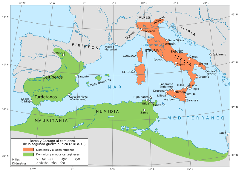
Descripción: Mapa de la República romana y del Imperio cartaginés antes de la Segunda Guerra Púnica.
Título: Map of Rome and Carthage at the start of the Second Punic War-es
Créditos: Map of Rome and Carthage at the start of the Second Punic War-pt.svg: Grandiose (discusión · contribs.)
Autor(a): Map of Rome and Carthage at the start of the Second Punic War-pt.svg: Grandiose (discusión · contribs.) derivative work: Rowanwindwhistler
Términos de Uso: Creative Commons Attribution-Share Alike 3.0
Licencia: CC BY-SA 3.0
Enlace de Licencia: https://creativecommons.org/licenses/by-sa/3.0
¿Se exige la atribución?: Sí
Usos del archivo
Las siguientes páginas enlazan a este archivo:

Todo el contenido de los artículos de la Enciclopedia Kiddle (incluidas las imágenes) se puede utilizar libremente para fines personales y educativos bajo la licencia Atribución-CompartirIgual a menos que se indique lo contrario.