
Archivo: Map of Land Ceded by Treaty of Fort Jackson
No disponible en mayor resolución.
Map_of_Land_Ceded_by_Treaty_of_Fort_Jackson.png (320 × 336 píxeles; tamaño de archivo: 11 KB; tipo MIME: image/png)
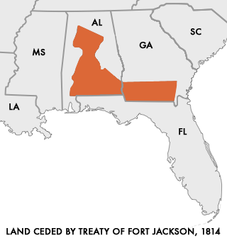
Descripción: Map of Land Ceded to the United States by the warring Creek Nations in the Treaty of Fort Jackson of 1814. User:Dystopos created this map using as reference a map "Creek Land Cessions Map 1733 through 1832" from the Horseshoe Bend National Military Park page on Areaparks.com [1]
Título: Map of Land Ceded by Treaty of Fort Jackson
Créditos: http://en.wikipedia.org/wiki/Image:Map_of_Land_Ceded_by_Treaty_of_Fort_Jackson.png
Autor(a): User:Dystopos
Permiso: No Rights Reserved
Términos de Uso: Dominio Público
Licencia: Dominio Público
¿Se exige la atribución?: No
Usos del archivo
Las siguientes páginas enlazan a este archivo:

Todo el contenido de los artículos de la Enciclopedia Kiddle (incluidas las imágenes) se puede utilizar libremente para fines personales y educativos bajo la licencia Atribución-CompartirIgual a menos que se indique lo contrario.