
Archivo: Map Padre Island towns
No disponible en mayor resolución.
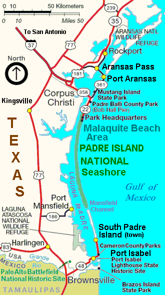
Map_Padre_Island_towns.gif (330 × 590 píxeles; tamaño de archivo: 35 KB; tipo MIME: image/gif)
Descripción: Map of Padre Island — showing the towns and parks on the Gulf Coast Barrier island in Texas. Includes the Padre Island National Seashore, and other Barrier islands: Mustang Island with Mustang Island State Park to the north, and Brazos Island to the south.
Título: Map Padre Island towns
Créditos: Cropped/labeled derivative version of file from U.S. National Park Service, URL: http://www.nps.gov/pais/planyourvisit/images/GMP_PAIS_cropped_to_415x600.jpg
Autor(a): Wikid77, revising map from U.S. National Park Service.
Términos de Uso: Dominio Público
Licencia: Dominio Público
¿Se exige la atribución?: No
Usos del archivo
La siguiente página enlaza a este archivo:

Todo el contenido de los artículos de la Enciclopedia Kiddle (incluidas las imágenes) se puede utilizar libremente para fines personales y educativos bajo la licencia Atribución-CompartirIgual a menos que se indique lo contrario.