
Archivo: M40 motorway (Great Britain) map

Tamaño de esta previsualización PNG del archivo SVG: 486 × 599 píxeles. Otra resolución: 195 × 240 píxeles.
Archivo original (archivo SVG, nominalmente 1038 × 1279 píxeles, tamaño de archivo: 457 KB)
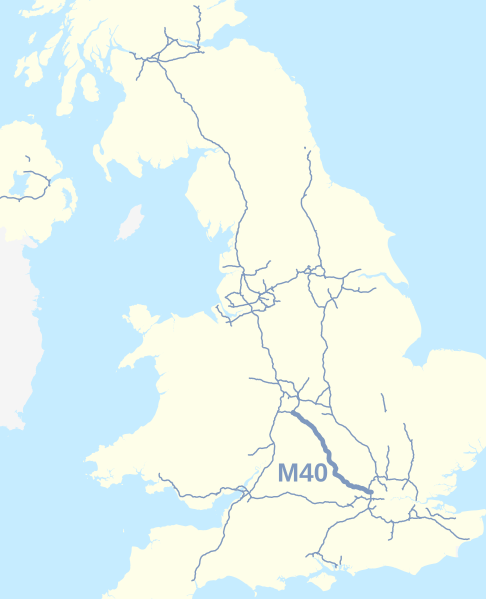
Description: Map of the M40 motorway of Great Britain highlighted against the motorways of the United Kingdom in 2016. Equirectangular map projection on WGS 84 datum.
Title: M40 motorway (Great Britain) map
Credit: This file was derived from: UK motorways map (thick lines).svg
Author: UK motorways map (thick lines).svg: User:Dr Greg and User:Nilfanion, created using Ordnance Survey and OpenStreetMap data derivative work: Dr Greg
Usage Terms: Creative Commons Attribution-Share Alike 4.0
License: CC BY-SA 4.0
License Link: https://creativecommons.org/licenses/by-sa/4.0
Attribution Required?: Yes
Usos del archivo
La siguiente página enlaza a este archivo:
_map.svg&oldid=1632700)

Todo el contenido de los artículos de la Enciclopedia Kiddle (incluidas las imágenes) se puede utilizar libremente para fines personales y educativos bajo la licencia Atribución-CompartirIgual a menos que se indique lo contrario.
_map.svg)