
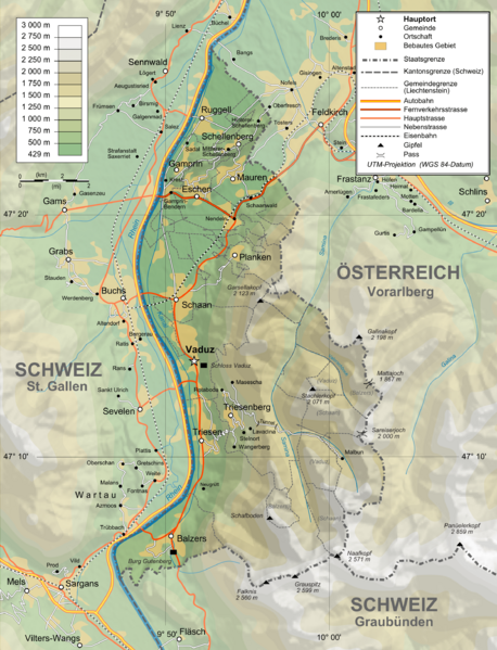
Archivo: Liechtenstein topographic map-de Version Tschubby

Descripción: Topographic map in German of Liechtenstein
Título: Liechtenstein topographic map-de Version Tschubby
Créditos: Own work ; Topographic data from the NASA Shuttle Radar Topography Mission (SRTM3 v.2) (public domain) edited with 3DEM and dlgv32 Pro, and vectorized with Inkscape ; UTM projection ; WGS84 datum ; shaded relief (N-W lightning positions) edited with The Gimp ; Reference used for the additional data : * Rivers, cities, railroads, routes, bathymetry : Demis add-on for World Wind (see the approval e-mail and the Demis forum) ; * Borders and coast : World data bank II + + File:Liechtenstein-admin.png by user:Aotearoa ; Approximate scale of topographic data : 1:1,463,000 ; Note : The shaded relief is a raster image embedded in the SVG file.
Autor(a): Bourrichon, translated by NordNordWest, new Design by Tschubby
Permiso: GFDL / Attribution and Share-Alike required
Términos de Uso: Creative Commons Attribution-Share Alike 4.0
Licencia: CC BY-SA 4.0
Enlace de Licencia: https://creativecommons.org/licenses/by-sa/4.0
¿Se exige la atribución?: Sí
Usos del archivo
La siguiente página enlaza a este archivo:
