
Archivo: Judaea Roman Province-es

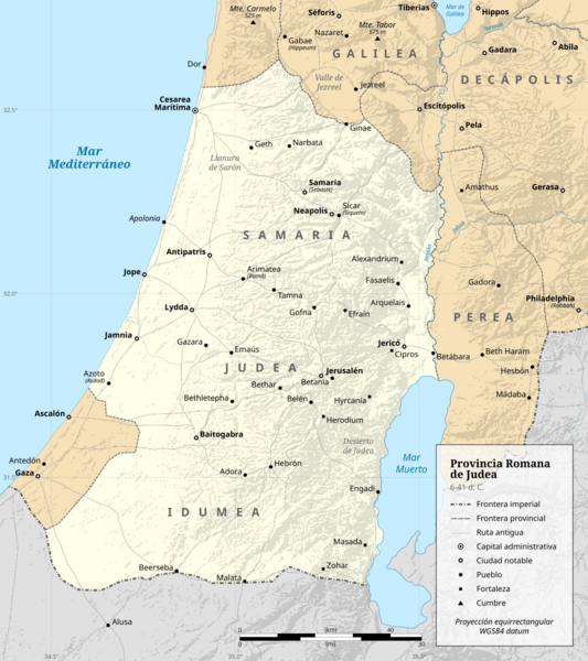
Descripción: Judaea Roman Province political map (AD 6–41)
Título: Mapa político de la provincia romana de Judea (6-41 d. C.)
Créditos: Trabajo propio. Este archivo deriva de: Judaea Roman Province.svg: Sources of data: Coastline, rivers and water bodies: GSHHG. Hillshade: NASA SRTM GL3. WGS 84 location coordinates: Digital Atlas of the Roman Empire. Ancient roads: Ancient World Mapping Center. Borders: Bryce, Trevor (2016) Atlas of the Ancient Near East, Nueva York: Routledge, p. 267 ISBN: 978-0-415-50800-1. Curtis, Adrian (2007) Oxford Bible Atlas, Oxford: Oxford University Press ISBN: 978‒0‒19‒100158‒1. Gelb, Norman (2013) Herod the Great: Statesman, Visionary, Tyrant, Lanham: Rowman & Littlefield ISBN: 978-1-4422-1065-3. Richardson, Peter (2018) Herod: King of the Jews and Friend of the Romans, Nueva York: Routledge ISBN: 978-1-138-80392-3. Smith, George Adam (1915) Atlas of the Historical Geography of the Holy Land, Londres: Hodder & Stoughton, p. 42 ISBN: 978-1-013-58494-7. Wright, Paul H. (2020) Ultimate Bible Atlas, Nashville: Holman Bible Publishers, p. 146−148 ISBN: 978-1-0877-3103-2.
Autor(a): DEGA MD
Términos de Uso: Creative Commons Attribution-Share Alike 4.0
Licencia: CC BY-SA 4.0
Enlace de Licencia: https://creativecommons.org/licenses/by-sa/4.0
¿Se exige la atribución?: Sí
Usos del archivo
La siguiente página enlaza a este archivo:
