
Archivo: Israel location map with stripes

Tamaño de esta previsualización PNG del archivo SVG: 322 × 598 píxeles. Otra resolución: 129 × 240 píxeles.
Archivo original (archivo SVG, nominalmente 614 × 1141 píxeles, tamaño de archivo: 170 KB)
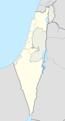
Description: English (en): The 1949 armistice line, aka the "Green Line" or "pre-67 borders" Borders of the Israeli-annexed East Jerusalem and Golan Heights Non-Israeli borders
Title: Israel location map with stripes
Credit: This file was derived from: Israel location map.svg
Author: Israel location map.svg: NordNordWest (talk) derivative work: Jackmcbarn (talk)
Permission: You may select the license of your choice.
Usage Terms: Creative Commons Attribution-Share Alike 3.0
License: CC BY-SA 3.0
License Link: https://creativecommons.org/licenses/by-sa/3.0
Attribution Required?: Yes
Usos del archivo
Las siguientes páginas enlazan a este archivo:

Todo el contenido de los artículos de la Enciclopedia Kiddle (incluidas las imágenes) se puede utilizar libremente para fines personales y educativos bajo la licencia Atribución-CompartirIgual a menos que se indique lo contrario.