
Archivo: Iceland Mid-Atlantic Ridge Fig16
No disponible en mayor resolución.
Iceland_Mid-Atlantic_Ridge_Fig16.gif (376 × 390 píxeles; tamaño de archivo: 9 KB; tipo MIME: image/gif)
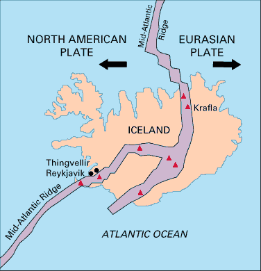
Description: Map showing the Mid-Atlantic Ridge splitting Iceland and separating the North American and Eurasian Plates. The map also shows Reykjavik, the capital of Iceland, the Thingvellir area, and the locations of some of Iceland's active volcanoes (red triangles), including Krafla.
Title: Iceland Mid-Atlantic Ridge Fig16
Credit: pubs.usgs.gov
Author: USGS
Usage Terms: Public domain
License: Public domain
Attribution Required?: No
Usos del archivo
Las siguientes páginas enlazan a este archivo:

Todo el contenido de los artículos de la Enciclopedia Kiddle (incluidas las imágenes) se puede utilizar libremente para fines personales y educativos bajo la licencia Atribución-CompartirIgual a menos que se indique lo contrario.