
Archivo: High Crosses of Ireland (map)

Tamaño de esta previsualización: 471 × 600 píxeles. Otras resoluciones: 188 × 240 píxeles | 1000 × 1273 píxeles.
Archivo original (1000 × 1273 píxeles; tamaño de archivo: 286 KB; tipo MIME: image/png)
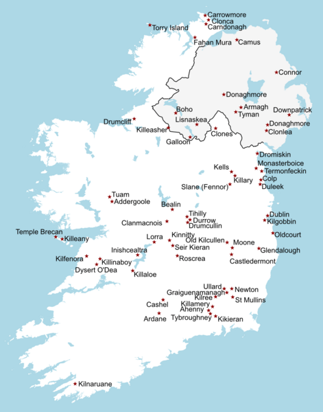
Description: Map illustrating the locations of existing High Crosses in Ireland (Rep of Ireland and Northern Ireland). I based this map off of the one shown here, which cites: "Harbison, Peter. Irish high crosses : with the figure sculptures explained. Illustrations by Hilary Gilmore. Drogheda : Boyne Valley Honey Company ; [Syracuse : Distributed by Syracuse University Press], 1994".
Author: Breandán MacAmhlaidh (talk)
Usage Terms: Creative Commons Attribution-Share Alike 3.0
License: CC-BY-SA-3.0
License Link: http://creativecommons.org/licenses/by-sa/3.0/
Attribution Required?: Yes
Usos del archivo
Las siguientes páginas enlazan a este archivo:
.png&oldid=2343301)

Todo el contenido de los artículos de la Enciclopedia Kiddle (incluidas las imágenes) se puede utilizar libremente para fines personales y educativos bajo la licencia Atribución-CompartirIgual a menos que se indique lo contrario.
.png)