
Archivo: HeadwatersGanges1

Tamaño de esta previsualización: 487 × 600 píxeles. Otras resoluciones: 195 × 240 píxeles | 2000 × 2464 píxeles.
Archivo original (2000 × 2464 píxeles; tamaño de archivo: 339 KB; tipo MIME: image/jpeg)
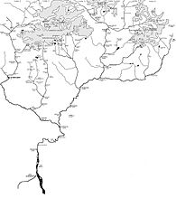
Description: Map showing the Himalayan headwaters of the Ganges river of the Indian subcontinent. The map is based on the map in . That map in turn is based on the map of the region produced by the Surveyor General of India.
Title: HeadwatersGanges1
Credit: Own work (Original text: I created this work entirely by myself.)
Author: Fowler&fowler«Talk»
Usage Terms: Creative Commons Attribution-Share Alike 3.0
License: CC BY-SA 3.0
License Link: http://creativecommons.org/licenses/by-sa/3.0
Attribution Required?: Yes
Usos del archivo
La siguiente página enlaza a este archivo:

Todo el contenido de los artículos de la Enciclopedia Kiddle (incluidas las imágenes) se puede utilizar libremente para fines personales y educativos bajo la licencia Atribución-CompartirIgual a menos que se indique lo contrario.