
Archivo: Hawaiianislandchain USGS
No disponible en mayor resolución.
Hawaiianislandchain_USGS.png (569 × 289 píxeles; tamaño de archivo: 7 KB; tipo MIME: image/png)
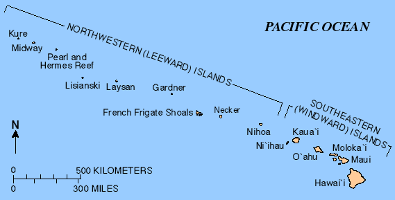
Description: Map of the Hawaiian Islands — a chain of volcanoes that stretches about 2,700 kilometres (1,700 mi) in a northwest direction, from the Island of Hawai'i and other Windward/Southeastern Main Hawaiian Islands, to the Leeward Northwestern Hawaiian Islands (Honolulu County).
Title: Hawaiianislandchain USGS
Credit: http://hvo.wr.usgs.gov/volcanoes/
Author: United States Geological Survey (USGS)
Usage Terms: Public domain
License: Public domain
Attribution Required?: No
Usos del archivo
Las siguientes páginas enlazan a este archivo:

Todo el contenido de los artículos de la Enciclopedia Kiddle (incluidas las imágenes) se puede utilizar libremente para fines personales y educativos bajo la licencia Atribución-CompartirIgual a menos que se indique lo contrario.