
Archivo: GolanHistoricalBorders-es

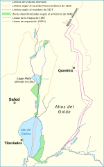
Descripción: Historical Golan Heights boundaries: Ottoman boundary between the vilayets of Beirut and Syria. Franco-British Boundary Agreement (1920). Boundary between the British Mandate of Palestine and the French Mandate of Syria (1923). 1949-1967 demilitarized zone and demarcation line between Israel and Syria. 1967 cease-fire lines. 1974 Disengagement lines.
Título: GolanHistoricalBorders-es
Créditos: GolanHistoricalBorders.svg
Autor(a): GolanHistoricalBorders.svg: Doron derivative work: Rowanwindwhistler (discusión)
Términos de Uso: Creative Commons Attribution-Share Alike 4.0
Licencia: CC BY-SA 4.0
Enlace de Licencia: https://creativecommons.org/licenses/by-sa/4.0
¿Se exige la atribución?: Sí
Usos del archivo
La siguiente página enlaza a este archivo:
