
Archivo: GB-Definition-Map
No disponible en mayor resolución.
GB-Definition-Map.jpg (286 × 392 píxeles; tamaño de archivo: 17 KB; tipo MIME: image/jpeg)
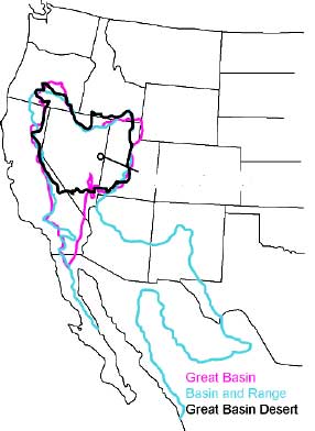
Description: The Great Basin can be defined hydrographically (in purple), topographically (in blue), or biologically (in black).
Title: GB-Definition-Map
Credit: http://www.nps.gov/grba/planyourvisit/the-great-basin.htm
Author: U.S. National Park Service
Permission: This image or media file contains material based on a work of a National Park Service employee, created as part of that person's official duties. As a work of the U.S. federal government, such work is in the public domain in the United States. See the NPS website and NPS copyright policy for more information.
Usage Terms: Public domain
License: Public domain
Attribution Required?: No
Usos del archivo
Las siguientes páginas enlazan a este archivo:

Todo el contenido de los artículos de la Enciclopedia Kiddle (incluidas las imágenes) se puede utilizar libremente para fines personales y educativos bajo la licencia Atribución-CompartirIgual a menos que se indique lo contrario.