
Archivo: Folketingsvalget 2019 - Afstemningsområder

Tamaño de esta previsualización PNG del archivo SVG: 510 × 412 píxeles. Otra resolución: 297 × 240 píxeles.
Archivo original (archivo SVG, nominalmente 510 × 412 píxeles, tamaño de archivo: 3,76 MB)
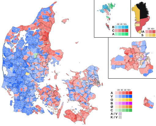
Descripción: A map showing the results of the 2019 Danish election within each polling area. The map shows the share of the vote won by the largest party. The black boundaries show the borders of the nomination districts. In the Faroe Islands and Greenland, the results are shown by municipality.
Título: Folketingsvalget 2019 - Afstemningsområder
Créditos: Trabajo propio
Autor(a): Gust Justice
Términos de Uso: Creative Commons Attribution-Share Alike 4.0
Licencia: CC BY-SA 4.0
Enlace de Licencia: https://creativecommons.org/licenses/by-sa/4.0
¿Se exige la atribución?: Sí
Usos del archivo
La siguiente página enlaza a este archivo:

Todo el contenido de los artículos de la Enciclopedia Kiddle (incluidas las imágenes) se puede utilizar libremente para fines personales y educativos bajo la licencia Atribución-CompartirIgual a menos que se indique lo contrario.