
Archivo: FatuIva topographic map-fr

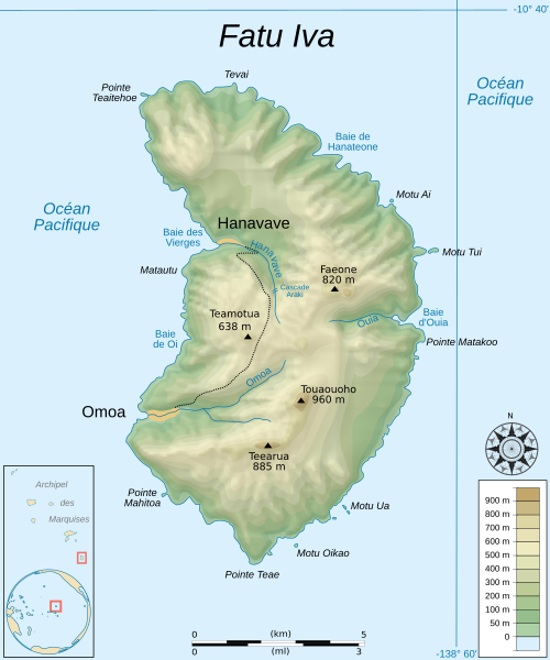
Descripción: Topographic map in French of the island of Fatu Hiva, Marquesas Islands, French Polynesia.
Título: FatuIva topographic map-fr
Créditos: Trabajo propio. Data sourcesBackground map : NASA Shuttle Radar Topography Mission (SRTM3 v.2) (public domain) Locator map : Earth from Polynesia-triangle.png (modified) created by Reisio under PD ; archipielago from Marquesas.map.svg (colored) created by Sarefo under CC-BY-SA ; compass rose from Compass rose pale.svg (opacified) created by Fibonacci under GFDL. Other references used for toponymes : maps available on cecile.barbet.free.fr and www.tahiti-tourisme.fr (2007-08-08).Softwares usedNASA datas edited with 3DEM from Visualization Software LLC Vectorized with Inkscape The Gimp ; Creation Map Tutorial (in french) from Sting (thanks to him)OthersUTM map projection WGS84 geodetic system shaded relief (composite image of N-W, W and N lightning positions).
Autor(a): Sémhur (talk)
Términos de Uso: Creative Commons Attribution-Share Alike 3.0
Licencia: CC BY-SA 3.0
Enlace de Licencia: https://creativecommons.org/licenses/by-sa/3.0
¿Se exige la atribución?: Sí
Usos del archivo
La siguiente página enlaza a este archivo:
