
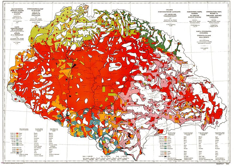
Archivo: Ethnographic map of hungary 1910 by teleki carte rouge

Tamaño de esta previsualización: 800 × 566 píxeles. Otras resoluciones: 320 × 226 píxeles | 4962 × 3509 píxeles.
Archivo original (4962 × 3509 píxeles; tamaño de archivo: 5,18 MB; tipo MIME: image/jpeg)
Description: Ethnographic map of Hungary, based on the density of population according to the census of 1910. Original scale 1 : 1 000 000. Every square millimeter colored indicates 100 inhabitants. "Carte Rouge" - "Red map" was made for the peace talk in Trianon.
Title: Ethnographic map of hungary 1910 by teleki carte rouge
Credit: Scanned from an original
Author: Paul Teleki (1879-1941)
Usage Terms: Public domain
License: Public domain
Attribution Required?: No
Usos del archivo
La siguiente página enlaza a este archivo:

Todo el contenido de los artículos de la Enciclopedia Kiddle (incluidas las imágenes) se puede utilizar libremente para fines personales y educativos bajo la licencia Atribución-CompartirIgual a menos que se indique lo contrario.