
Archivo: Dufour République fédérative des états-unis méxicains 1835 UTA
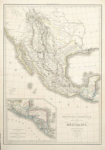
Descripción: Interestingly, the short-lived Fredonian Rebellion of 1826-1827 – a precursor to the Texas War of Independence – had a longer life in popular culture than in reality, in part thanks to outdated European maps depicting the U.S.-Mexico borderlands. This 1835 map by Dufour bears the following notation in French: "Republic of Fredonia formed by the Province of Texas and established December 16, 1826." This Fredonian Rebellion grew out of a land dispute between the Mexican government and the two Anglo-Texan empresarios Haden Edwards and his brother Benjamin. Their 1825 land grant included areas that had already been settled, creating chaos between older colonists, the Edwards brothers, and their "new" colonists. As Mexican government officials attempted to clear up the problem, the Edwards brothers and their supporters holed up in an old stone fort at Nacogdoches and, on December 16, 1826, declared an independent state they called "Fredonia". Mexican authorities, aided by other Anglo colonists, quickly crushed the rebellion and forced the Edwards brothers and their supporters to flee across the border to Louisiana by February 1827. Interestingly, prominently located on the map in Fredonia (or southeast Texas) is the site of Champ d’Asìle ("Field of Asylum") a reference to a failed colony of French Napoleonic veterans dating back to 1818. The map lists numerous Indian groups in Texas, New Mexico, and beyond, all spelled phonetically in French.
Título: République fédérative des états-unis méxicains
Créditos: UTA Libraries Cartographic Connections: map / texto
Autor(a): Auguste Henri Dufour
Términos de Uso: Dominio Público
Licencia: Dominio Público
¿Se exige la atribución?: No
Usos del archivo
La siguiente página enlaza a este archivo:
