
Archivo: Detailed Afroasiatic map

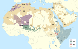
Description: Detailed map of Afroasiatic languages in Africa and the Middle East. This file was derived from: Africa map blank.svg Sources (Wikipedia): Files: Tachelhit.png, Carthe ethnolinguistique - Nord et Est du Maroc.PNG, Tunisia-Zuwara Berber Map.PNG, Aires linguistiques du nord-est algérien.svg, Hassaniya Arabic Map.svg and Africa ethnic groups 1996.jpg External sources: L. Berry, "Sudan, a country study" V Brugnatelli and M Lafkioui, "Negation in Berber: variation, evolution, and typology" V. de Colombel, "Uldeme/Wuzlam Corpus" Ethnologue Middle East [1] [2] East Africa [3] [4] [5] [6] West and Central Africa [7] [8] [9] [10] Arabian Peninsula [11] [12] North Africa [13] [14] M. Felix and C. Meur, "Peoples of Africa"[15] W. Heinrichs "Studies in Neo-Aramaic" M. Izady, Infographs, Maps and Statistics Collection K. Küspert, "The Mao and Komo Languages in the Begi–Tongo area in Western Ethiopia: Classification, Designations, Distribution" S. Manfredi and S. Petrollino, "Juba Arabic" R. Meyer and H. E. Wolff, "Comparative and Descriptive African Linguistics"[16] S. Petrollino, "A grammar of Hamar : a South Omotic language of Ethiopia" J. Philips, "Map of West Chadic language distribution" T. Roettger, "Tonal placement in Tashlhiyt: How an intonation system accommodates to adverse phonological environments" R. Schuh, in "Being and Becoming Hausa" J. Smolders, "A Phonology of Ganza (Gwàmì Nánà)" Y. Treis, Switch-reference and Omotic-Cushitic Language Contact in Southwest Ethiopia
Title: Detailed Afroasiatic map
Credit: Own work
Author: Noahedits
Usage Terms: Creative Commons Attribution-Share Alike 4.0
License: CC BY-SA 4.0
License Link: https://creativecommons.org/licenses/by-sa/4.0
Attribution Required?: Yes
Usos del archivo
La siguiente página enlaza a este archivo:
