
Archivo: Cologne War 1

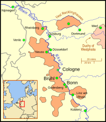
Descripción: A map of the Electorate of Cologne showing major cities of the Electorate (Cologne, Bruhl, Bonn) as well as towns involved in the War and other important cities in the area. The gray lines show modern day national borders. Except for the Emscher river, the rivers are shown in their modern routes/channels/paths. This map uses a Mercator projection.
Título: Cologne War 1
Créditos: Trabajo propio utilizando: Outline of the Electorate: Willem and Joan(nes) Blaeu's 1645 map File:Blaeu 1645 - Coloniensis Archiepiscopatus.jpg
Autor(a): MapMaster
Términos de Uso: Creative Commons Attribution 3.0
Licencia: CC BY 3.0
Enlace de Licencia: https://creativecommons.org/licenses/by/3.0
¿Se exige la atribución?: Sí
Usos del archivo
La siguiente página enlaza a este archivo:
